IMAGES TAKEN NEAR TO
Hardwick Rise, SUNDERLAND, SR6 0QF
Introduction
This page details the photographs taken nearby to Hardwick Rise, SR6 0QF by members of the Geograph project.
The Geograph project started in 2005 with the aim of publishing, organising and preserving representative images for every square kilometre of Great Britain, Ireland and the Isle of Man.

There are currently over 7.5m images from over14,400 individuals and you can help contribute to the project by visiting https://www.geograph.org.uk
Image Map
Images are licensed for reuse under creativecommons.org/licenses/by-sa/2.0
Notes
- Clicking on the map will re-center to the selected point.
- The higher the marker number, the further away the image location is from the centre of the postcode.
Image Listing (160 Images Found)
Images are licensed for reuse under creativecommons.org/licenses/by-sa/2.0
Image
Details
Distance
1
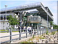
Red Room
A sculpture near The National Glass Centre.
Image: © Mick Garratt
Taken: 2 May 2011
0.04 miles
2
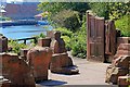
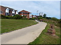
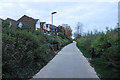
Riverside footpath, Sunderland
A footpath follows the northern river bank of the River Wear.
Image: © Graham Robson
Taken: 9 Oct 2016
0.04 miles
3
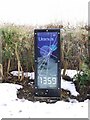
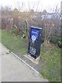
Cycle route waymarker by Andrew Small near Sunderland Marina
The lenticular display shows the distance to the end of the C2C and W2W long-distance cycle routes and features the planet Uranus orbiting the sun. The planet appears to move round its orbit, and the distance clicks down, as you pass the panel. Other planets are represented in the final mile of the route to their finish at Roker Beach and are sited at their relative distances from the artist's sculpture 'Second Sun', situated below Wearmouth Bridge Image], ending with 'Pluto' at the finish.
Andrew Small: http://www.andrewsmall.org.uk/Andrew_Small/Blog/Blog.html
Image: © Andrew Curtis
Taken: 10 Dec 2010
0.04 miles
4
Final Climb of the Coast to Coast Cycle Trail
Or the first downhill bit, depending on which way you go.
Part of the National Cycleway No. 7.
Image: © Mick Garratt
Taken: 2 May 2011
0.05 miles
5
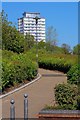
England Coast Path in Sunderland
Along the north bank of the River Wear.
Image: © Mat Fascione
Taken: 27 Aug 2017
0.05 miles
7
"Uranus" on the W2W
A number of artworks have been placed along the final stretch of the Walney to Wear cycle route along the north bank of the River Wear. A "second sun" is located under Wearmouth Bridge and displays representing the planets have been located ar their relative distances, finishing at "Pluto" on Roker Promenade. For more details about the display itself, see Image
Other installations representing the solar system can be seen on the York to Selby Cycle Path Image and, rather less convincingly, in the Almondell and River Calder Country Park to the west of Edinburgh Image
Image: © Oliver Dixon
Taken: 23 Feb 2016
0.05 miles
8
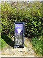
"Uranus" on the W2W
Component of a representation of the solar system at a scale of approximately 1:2,000,000,000. Boards representing the planets are sited at their relative distances along the north bank of the Wear on the final stretch of the Walney to Wear cycle route, starting with the "Second Sun" Image under Wearmouth Bridge and finishing with Pluto (which strictly speaking is now defined as only a "minor planet") at Roker Pier.
See also Image
Image: © Oliver Dixon
Taken: 25 Mar 2019
0.05 miles
9
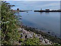
The English Coast Path near the River Wear
I was hoping for a view over the river, but none was available on this stretch.
Image: © Bill Boaden
Taken: 22 Apr 2017
0.06 miles
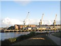
10
Mouth of the River Wear in Sunderland
Image: © Mat Fascione
Taken: 27 Aug 2017
0.06 miles