IMAGES TAKEN NEAR TO
Rosyth Road, SUNDERLAND, SR5 5LE
Introduction
This page details the photographs taken nearby to Rosyth Road, SR5 5LE by members of the Geograph project.
The Geograph project started in 2005 with the aim of publishing, organising and preserving representative images for every square kilometre of Great Britain, Ireland and the Isle of Man.

There are currently over 7.5m images from over14,400 individuals and you can help contribute to the project by visiting https://www.geograph.org.uk
Image Map
Images are licensed for reuse under creativecommons.org/licenses/by-sa/2.0
Notes
- Clicking on the map will re-center to the selected point.
- The higher the marker number, the further away the image location is from the centre of the postcode.
Image Listing (5 Images Found)
Images are licensed for reuse under creativecommons.org/licenses/by-sa/2.0
Image
Details
Distance
2

Cemetery at Marley Potts, Sunderland
Very well tended. In the middle of a large council housing estate.
Image: © Brian Abbott
Taken: 11 May 2006
0.23 miles
3
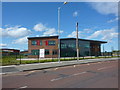
Maplewood School
On Redcar Road / Ramsgate Road - now closed, or moved to a new building.
Image: © Richard Webb
Taken: 9 Aug 2016
0.23 miles
4
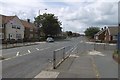
Redcar Road
Junction with Ramsgate Road.
Image: © Richard Webb
Taken: 9 Aug 2016
0.24 miles
5
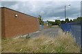
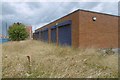
Maplewood School
Looks recently closed or moved.
Image: © Richard Webb
Taken: 9 Aug 2016
0.24 miles