IMAGES TAKEN NEAR TO
Wayfarer Road, SUNDERLAND, SR5 3XA
Introduction
This page details the photographs taken nearby to Wayfarer Road, SR5 3XA by members of the Geograph project.
The Geograph project started in 2005 with the aim of publishing, organising and preserving representative images for every square kilometre of Great Britain, Ireland and the Isle of Man.

There are currently over 7.5m images from over14,400 individuals and you can help contribute to the project by visiting https://www.geograph.org.uk
Image Map
Images are licensed for reuse under creativecommons.org/licenses/by-sa/2.0
Notes
- Clicking on the map will re-center to the selected point.
- The higher the marker number, the further away the image location is from the centre of the postcode.
Image Listing (27 Images Found)
Images are licensed for reuse under creativecommons.org/licenses/by-sa/2.0
Image
Details
Distance
2
The C2C at the northern end of the Queen Alexandra Bridge
The world-famous C2C cycle route passes by means of subways through the middle of the gyratory system on the A1231.
Image: © Oliver Dixon
Taken: 19 Jun 2015
0.11 miles
3

The C2C cycle route dropping down to the River Wear
Stadium of Light (Sunderland Football Club) in the background
Image: © Oliver Dixon
Taken: 7 Jun 2003
0.11 miles
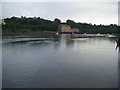
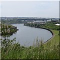
5
River Wear at Sunderland
This view looks upstream along the River Wear. In the background is the Queen Alexandra Bridge and behind it, a shipyard.
Image: © Malc McDonald
Taken: 8 Mar 2014
0.13 miles
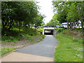
6
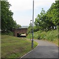
Cycle path, Southwick
It is using the trackbed of the Hylton, Southwick and Monk Wearmouth branch of the North Eastern Railway.
Image: © Richard Webb
Taken: 18 Jun 2013
0.15 miles
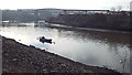
7
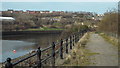
Path on the river bank, Sunderland
This path along the bank of the River Wear has become quite overgrown. It continues for a short distance before reaching a dead end.
Image: © Malc McDonald
Taken: 8 Mar 2014
0.15 miles
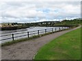
8
River Wear
View upstream towards the Queen Alexandra Bridge from Kier Hardie Way.
Image: © Richard Webb
Taken: 18 Jun 2013
0.16 miles
9
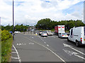
Traffic at the northern end of Queen Alexandra Bridge
Streams of traffic waiting at lights to enter the gyratory system.
Image: © Oliver Dixon
Taken: 19 Jun 2015
0.16 miles
10
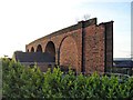
Railway viaduct, Queen Alexandra Bridge
Formerly the railway approach to Queen Alexandra Bridge, this viaduct now stands in rather forlorn isolation.
Image: © Antony Dixon
Taken: 13 Jan 2012
0.18 miles