IMAGES TAKEN NEAR TO
Cricklewood Road, SUNDERLAND, SR5 3SP
Introduction
This page details the photographs taken nearby to Cricklewood Road, SR5 3SP by members of the Geograph project.
The Geograph project started in 2005 with the aim of publishing, organising and preserving representative images for every square kilometre of Great Britain, Ireland and the Isle of Man.

There are currently over 7.5m images from over14,400 individuals and you can help contribute to the project by visiting https://www.geograph.org.uk
Image Map
Images are licensed for reuse under creativecommons.org/licenses/by-sa/2.0
Notes
- Clicking on the map will re-center to the selected point.
- The higher the marker number, the further away the image location is from the centre of the postcode.
Image Listing (6 Images Found)
Images are licensed for reuse under creativecommons.org/licenses/by-sa/2.0
Image
Details
Distance
1
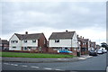
Houses on Ferryboat Lane
At the junction with Cricklewood Road.
Image: © JThomas
Taken: 18 Aug 2018
0.07 miles
2
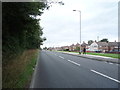
Ferryboat Lane
Looking north, adjacent to the A19.
Image: © JThomas
Taken: 18 Aug 2018
0.09 miles
3
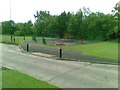
Play area, Cricklewood Road, Hylton Castle
Image: © Alex McGregor
Taken: 12 Jul 2011
0.13 miles
5
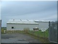
North East Aircraft Museum
The museum began life back in 1974. It now hosts around 40 aircraft from different ages. Further information about the museum ca be obtained from http://www.neam.co.uk
Image: © Steve McShane
Taken: 5 Nov 2005
0.25 miles
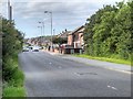
6
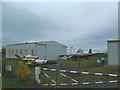
Hangars and Aircraft
Another view of the North East Aircraft Museum.
Image: © Steve McShane
Taken: 5 Nov 2005
0.25 miles