IMAGES TAKEN NEAR TO
Nissan Way, SUNDERLAND, SR5 3NY
Introduction
This page details the photographs taken nearby to Nissan Way, SR5 3NY by members of the Geograph project.
The Geograph project started in 2005 with the aim of publishing, organising and preserving representative images for every square kilometre of Great Britain, Ireland and the Isle of Man.

There are currently over 7.5m images from over14,400 individuals and you can help contribute to the project by visiting https://www.geograph.org.uk
Image Map
Images are licensed for reuse under creativecommons.org/licenses/by-sa/2.0
Notes
- Clicking on the map will re-center to the selected point.
- The higher the marker number, the further away the image location is from the centre of the postcode.
Image Listing (6 Images Found)
Images are licensed for reuse under creativecommons.org/licenses/by-sa/2.0
Image
Details
Distance
1
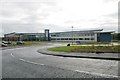
Tyne & Wear Fire & Rescue Service Headquarters
Tyne & Wear Fire & Rescue Service Headquarters, Nissan Way, Barmston Mere, Sunderland, Tyne & Wear, is designed along the same lines as many of the new Tyne & Wear fire stations built recently.
Image: © Kevin Hale
Taken: 26 Nov 2006
0.17 miles
3
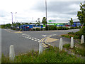
Asda Recycles, Pattinson Industrial Estate
Recycling centre, opened in 2008, to process cardboard waste and plastic food trays from Asda stores.
Image: © Oliver Dixon
Taken: 19 Jun 2015
0.23 miles
5
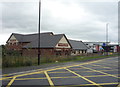
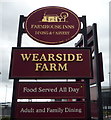
The Wearside Farm public house
On Turbine Way, Turbine Business Park.
Image: © JThomas
Taken: 18 Aug 2018
0.25 miles
6
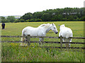
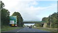
Two dapple greys beside the C2C
Two dapple greys in a paddock beside the C2C cycle route at the south-east corner of Washington. These horses are probably quite elderly as greys tend to turn white with age. A billboard suggests that this field is up for redevelopment - despite the rustic outlook, there are many industrial premises nearby.
Image: © Oliver Dixon
Taken: 19 Jun 2015
0.25 miles