IMAGES TAKEN NEAR TO
Wessington Way, SUNDERLAND, SR5 3NU
Introduction
This page details the photographs taken nearby to Wessington Way, SR5 3NU by members of the Geograph project.
The Geograph project started in 2005 with the aim of publishing, organising and preserving representative images for every square kilometre of Great Britain, Ireland and the Isle of Man.

There are currently over 7.5m images from over14,400 individuals and you can help contribute to the project by visiting https://www.geograph.org.uk
Image Map
Images are licensed for reuse under creativecommons.org/licenses/by-sa/2.0
Notes
- Clicking on the map will re-center to the selected point.
- The higher the marker number, the further away the image location is from the centre of the postcode.
Image Listing (11 Images Found)
Images are licensed for reuse under creativecommons.org/licenses/by-sa/2.0
Image
Details
Distance
1
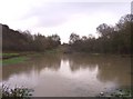
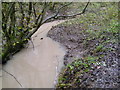
Hylton Dene
Hylton Dene Burn flows into this lake at the eastern edge of Hylton Dene.
Image: © Weston Beggard
Taken: 4 Dec 2005
0.15 miles
2
Hylton Dene + unwelcome guest
This shot of Hylton Dene is not improved by the gesticulating presence of fellow Geograph contributor, Mark Smiles ( http://www.geograph.org.uk/profile.php?u=2363 )
Image: © Weston Beggard
Taken: 4 Dec 2005
0.15 miles
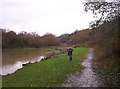
3
Bridge Over Hylton Dene With Geograph Cohort
Small footbridge over the mighty Hylton Dene with fellow contributor CG Burke http://www.geograph.org.uk/profile.php?u=2239 in full Geograph pose.
Image: © MSX
Taken: 4 Dec 2005
0.15 miles
4
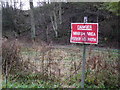
Hylton Dene Danger Zone
I swore I heard Donald Pleasance's voice saying, "I'll be BACK, back, back!" when I saw this tableau.
Image: © MSX
Taken: 4 Dec 2005
0.15 miles
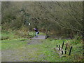
5
Hard Won Glory
I climbed over a wall, scrabbled down a muddy bank through brambles and lost my mobile phone to bring you a picture of the majestic Hylton Dene.
It looks more impressive on the map.
Image: © MSX
Taken: 4 Dec 2005
0.15 miles
6
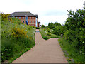
C2C approaching Sunderland
The world-famous C2C cycle route follows the north bank of the Wear approaching Sunderland. Modern office blocks overlook the path. One of the concrete sculptures which stand along the path can be seen.
Image: © Oliver Dixon
Taken: 19 Jun 2015
0.19 miles
7
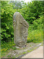
Sculpture beside the C2C
This cast concrete sculpture stands beside the world-famous C2C cycle route along the north bank of the River Wear. It almost certainly graced the River Wear Trail which predated the establishment of the C2C.
Image: © Oliver Dixon
Taken: 19 Jun 2015
0.21 miles
9

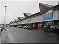
Timber Beach Road
A colliery site, now occupied by a tin shed retail park.
Image: © Richard Webb
Taken: 18 Jun 2013
0.22 miles
10
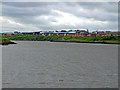
River Wear and riverside offices
Behind the offices (all built in the 1990s) can be seen the wind farm on the Nissan car factory premises.
The river is tidal at this point. At low tide a lot of mud would be visible!
Image: © Brian Abbott
Taken: 19 May 2006
0.24 miles