IMAGES TAKEN NEAR TO
Alexandra Avenue, SUNDERLAND, SR5 2TB
Introduction
This page details the photographs taken nearby to Alexandra Avenue, SR5 2TB by members of the Geograph project.
The Geograph project started in 2005 with the aim of publishing, organising and preserving representative images for every square kilometre of Great Britain, Ireland and the Isle of Man.

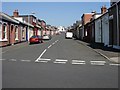
There are currently over 7.5m images from over14,400 individuals and you can help contribute to the project by visiting https://www.geograph.org.uk
Image Map
Images are licensed for reuse under creativecommons.org/licenses/by-sa/2.0
Notes
- Clicking on the map will re-center to the selected point.
- The higher the marker number, the further away the image location is from the centre of the postcode.
Image Listing (11 Images Found)
Images are licensed for reuse under creativecommons.org/licenses/by-sa/2.0
Image
Details
Distance
1
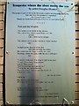
Explanatory plaque on Alexandra Avenue powerhouse
Image: © Antony Dixon
Taken: 6 Aug 2013
0.05 miles
2
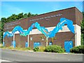
Poetic powerhouse on Alexandra Avenue
This building appears to be something to do with electricity supply. It has been decorated with artwork by Douglas Hunter and poetry by Ezra Pound. Further information and the full text of the poem are given on a plaque on the building - see Image]
Image: © Antony Dixon
Taken: 6 Aug 2013
0.05 miles
3
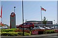
Bristol Street Motors
Leaving Silverbriar.
Image: © Steve Fareham
Taken: 5 Jun 2008
0.07 miles
4
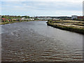
The River Wear downstream of the Northern Spire Bridge
Photo taken from Image
Image: © Mike Quinn
Taken: 26 Sep 2019
0.14 miles
5
Darwin Street, Southwick, Sunderland
Single-storey 2-bedroom houses, typical of many in this area and dating from the turn of the 20th century.
Image: © Brian Abbott
Taken: 11 May 2006
0.17 miles
6
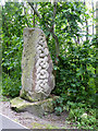
Sculpture beside the C2C
This cast concrete sculpture stands beside the world-famous C2C cycle route near the north bank of the River Wear. It almost certainly graced the River Wear Trail which predated the establishment of the C2C.
Image: © Oliver Dixon
Taken: 19 Jun 2015
0.17 miles
7
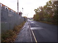
Riverside Road
Looking east along Riverside Road, home to much light industry.
Image: © Weston Beggard
Taken: 4 Dec 2005
0.18 miles
8
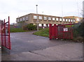
Devere Building
One of the many industrial concerns clustered around the Riverside Road area.
Image: © Weston Beggard
Taken: 4 Dec 2005
0.18 miles
9
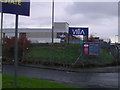
Pop Factory
This is where they make the locally famous Villa range of pops. Ironically some local japesters lobbed a half-full can of Barr's Irn-Bru at us from their speeding 4X4 just prior to us finding this factory.
Image: © MSX
Taken: 4 Dec 2005
0.18 miles
10
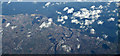
Sunderland from the air
The River Wear is the most prominent feature. Viewed from an Amsterdam bound flight from Glasgow.
Image: © Thomas Nugent
Taken: 2 Mar 2015
0.18 miles