IMAGES TAKEN NEAR TO
Carley Road, SUNDERLAND, SR5 2RN
Introduction
This page details the photographs taken nearby to Carley Road, SR5 2RN by members of the Geograph project.
The Geograph project started in 2005 with the aim of publishing, organising and preserving representative images for every square kilometre of Great Britain, Ireland and the Isle of Man.

There are currently over 7.5m images from over14,400 individuals and you can help contribute to the project by visiting https://www.geograph.org.uk
Image Map
Images are licensed for reuse under creativecommons.org/licenses/by-sa/2.0
Notes
- Clicking on the map will re-center to the selected point.
- The higher the marker number, the further away the image location is from the centre of the postcode.
Image Listing (29 Images Found)
Images are licensed for reuse under creativecommons.org/licenses/by-sa/2.0
Image
Details
Distance
1
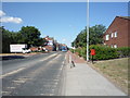
Southwick Road (B1291), Sunderland
Showing position of Postbox No. SR5 4.
See Image] for postbox.
Image: © JThomas
Taken: 7 Jul 2018
0.04 miles
2
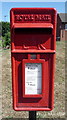
Close up, Elizabeth II postbox on Southwick Road, Sunderland
Postbox No. SR5 4.
See Image] for wider view.
Image: © JThomas
Taken: 7 Jul 2018
0.04 miles
3
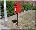
Elizabeth II postbox on Southwick Road, Sunderland
Image: © JThomas
Taken: 7 Jul 2018
0.04 miles
6
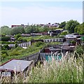
Allotments, Southwick
On steep slopes above the River Wear.
Image: © Richard Webb
Taken: 18 Jun 2013
0.11 miles
7
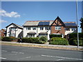
Halfway House
Pub, Keir Hardie Way, Sunderland. Looks like a survivor from when there were older houses here.
Image: © Richard Webb
Taken: 9 Aug 2016
0.12 miles
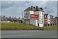
10
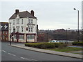
Halfway House, Southwick, Sunderland
The Halfway House pub in Southwick, in Sunderland. The River Wear is visible to the right of the image, with Sunderland city centre in the distance.
Image: © Malc McDonald
Taken: 4 Apr 2015
0.15 miles