IMAGES TAKEN NEAR TO
Carlisle Terrace, SUNDERLAND, SR5 2DF
Introduction
This page details the photographs taken nearby to Carlisle Terrace, SR5 2DF by members of the Geograph project.
The Geograph project started in 2005 with the aim of publishing, organising and preserving representative images for every square kilometre of Great Britain, Ireland and the Isle of Man.

There are currently over 7.5m images from over14,400 individuals and you can help contribute to the project by visiting https://www.geograph.org.uk
Image Map
Images are licensed for reuse under creativecommons.org/licenses/by-sa/2.0
Notes
- Clicking on the map will re-center to the selected point.
- The higher the marker number, the further away the image location is from the centre of the postcode.
Image Listing (13 Images Found)
Images are licensed for reuse under creativecommons.org/licenses/by-sa/2.0
Image
Details
Distance
1
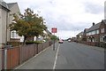
Oaklands Crescent, Sunderland
The markings painted on the road indicate that this road has a speed limit of 20 miles per hour.
Image: © Malc McDonald
Taken: 20 Apr 2014
0.09 miles
2
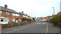
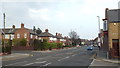
Oaklands Crescent, Sunderland
The speed limit on Oaklands Crescent is 20 miles per hour. On the road which goes across, the speed limit is 30mph. This results in two sets of speed limit signs, one each side of the junction.
Image: © Malc McDonald
Taken: 20 Apr 2014
0.10 miles
4
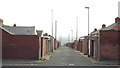
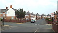
Back alley in Sunderland
This alley passes along the back of two rows of houses.
Image: © Malc McDonald
Taken: 20 Apr 2014
0.12 miles
8
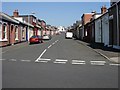
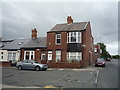
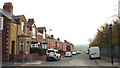
Darwin Street, Southwick, Sunderland
Single-storey 2-bedroom houses, typical of many in this area and dating from the turn of the 20th century.
Image: © Brian Abbott
Taken: 11 May 2006
0.16 miles
9
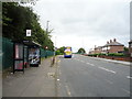
Bus stop and shelter on North Hylton Road, Sunderland
Passing Megabus did not stop.
Image: © JThomas
Taken: 18 Aug 2018
0.20 miles