IMAGES TAKEN NEAR TO
Herbert Terrace, SUNDERLAND, SR5 1RL
Introduction
This page details the photographs taken nearby to Herbert Terrace, SR5 1RL by members of the Geograph project.
The Geograph project started in 2005 with the aim of publishing, organising and preserving representative images for every square kilometre of Great Britain, Ireland and the Isle of Man.

There are currently over 7.5m images from over14,400 individuals and you can help contribute to the project by visiting https://www.geograph.org.uk
Image Map
Images are licensed for reuse under creativecommons.org/licenses/by-sa/2.0
Notes
- Clicking on the map will re-center to the selected point.
- The higher the marker number, the further away the image location is from the centre of the postcode.
Image Listing (18 Images Found)
Images are licensed for reuse under creativecommons.org/licenses/by-sa/2.0
Image
Details
Distance
1
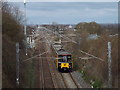
Tyne & Wear Metro near Fulwell, Sunderland
A Tyne & Wear Metro train between East Boldon and Seaburn stations. It is on a section of line shared with passenger and freight trains on the national rail network. The line is electrified using overhead cables.
Image: © Malc McDonald
Taken: 4 Apr 2015
0.02 miles
2
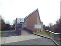
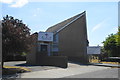
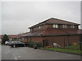
The New Church, Seaburn Dene, near Sunderland
The New Church at Seaburn Dene, to the north of Sunderland.
Image: © Malc McDonald
Taken: 4 Apr 2015
0.04 miles
4
Lane near Fulwell, Sunderland
The blue signpost indicates that this lane is a shared route for cyclists and pedestrians.
Image: © Malc McDonald
Taken: 4 Apr 2015
0.07 miles
6
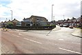
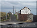
The junction of Dovedale Road and Alston Crescent
A junction of residential roads in the Seaburn area. The Dene pub stands on the corner of the junction.
Image: © Graham Robson
Taken: 23 Sep 2018
0.12 miles
7
Haversham Park, Fulwell, Sunderland
Haversham Park is a recent housing development in Fulwell, to the north of Sunderland.
Image: © Malc McDonald
Taken: 4 Apr 2015
0.13 miles
8
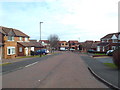
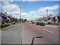
Dovedale Road, Seaburn Dene, near Sunderland
Dovedale Road in Seaburn Dene, on the northern outskirts of Sunderland.
Image: © Malc McDonald
Taken: 4 Apr 2015
0.13 miles
10
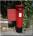
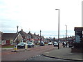
Elizabeth II postbox on Dovedale Road, Sunderland
Postbox No. SR6 241.
Image: © JThomas
Taken: 7 Jul 2018
0.14 miles