IMAGES TAKEN NEAR TO
Honister Drive, SUNDERLAND, SR5 1PA
Introduction
This page details the photographs taken nearby to Honister Drive, SR5 1PA by members of the Geograph project.
The Geograph project started in 2005 with the aim of publishing, organising and preserving representative images for every square kilometre of Great Britain, Ireland and the Isle of Man.

There are currently over 7.5m images from over14,400 individuals and you can help contribute to the project by visiting https://www.geograph.org.uk
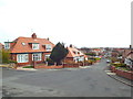
Image Map
Images are licensed for reuse under creativecommons.org/licenses/by-sa/2.0
Notes
- Clicking on the map will re-center to the selected point.
- The higher the marker number, the further away the image location is from the centre of the postcode.
Image Listing (57 Images Found)
Images are licensed for reuse under creativecommons.org/licenses/by-sa/2.0
Image
Details
Distance
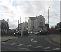
2
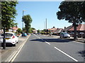
Charlton Road, Sunderland
Looking north east on the B1291.
Image: © JThomas
Taken: 7 Jul 2018
0.07 miles
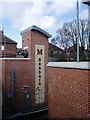
3
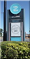
Sign for the Grange public house, Sunderland
A Sizzling Pub & Grill.
Image: © JThomas
Taken: 7 Jul 2018
0.07 miles

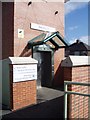
5
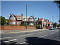
The Grange public house, Sunderland
On Newcastle Road.
Image: © JThomas
Taken: 7 Jul 2018
0.09 miles
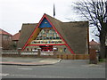
6
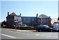
High View Nursery in Viewforth Terrace, Fulwell
Image: © Peter Robinson
Taken: 14 Oct 2012
0.09 miles
7
Seaburn Metro Station, Fulwell, Sunderland, 17th April 2006
Image: © Martin Routledge
Taken: 17 Apr 2006
0.10 miles
8
Seaburn Metro Station, Fulwell, Sunderland, 17th April 2006
Image: © Martin Routledge
Taken: 17 Apr 2006
0.10 miles
10
Mill Bank, Fulwell, Sunderland
Mill Bank in Fulwell, to the north of Sunderland, looking eastwards towards the sea less than a mile away.
Image: © Malc McDonald
Taken: 4 Apr 2015
0.11 miles