IMAGES TAKEN NEAR TO
Richmond Street, SUNDERLAND, SR5 1BQ
Introduction
This page details the photographs taken nearby to Richmond Street, SR5 1BQ by members of the Geograph project.
The Geograph project started in 2005 with the aim of publishing, organising and preserving representative images for every square kilometre of Great Britain, Ireland and the Isle of Man.

There are currently over 7.5m images from over14,400 individuals and you can help contribute to the project by visiting https://www.geograph.org.uk
Image Map
Images are licensed for reuse under creativecommons.org/licenses/by-sa/2.0
Notes
- Clicking on the map will re-center to the selected point.
- The higher the marker number, the further away the image location is from the centre of the postcode.
Image Listing (166 Images Found)
Images are licensed for reuse under creativecommons.org/licenses/by-sa/2.0
Image
Details
Distance
1
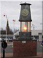
Miner's lamp, Stadium of Light, Sunderland
Close to the new stadium, and the adjacent swimming pool, was the Pemberton Pit (see http://www.dmm.org.uk/colliery/w001.htm ) which for years boasted the deepest mine shaft in the world at 1794'. The miner's lamp is therefore a pertinent symbol of Sunderland's past.
Image: © rob bishop
Taken: 18 Mar 2006
0.06 miles
2
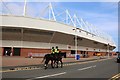
The South Stand at the Stadium of Light
The Stadium of Light is the home of Sunderland F.C.
Image: © Steve Daniels
Taken: 3 Aug 2019
0.08 miles
3
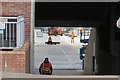
Roadies, Stadium of Light
Concert season at the stadium and preparations are being made for Rhianna. Time to find that bunker around another planet.
The name of the stadium is actually original. The Lisbon example is a poor press pun on the name of Luz, a suburb.
Image: © Richard Webb
Taken: 18 Jun 2013
0.09 miles
4
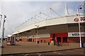
The South Stand at the Stadium of Light
The Stadium of Light is the home of Sunderland F.C.
Image: © Steve Daniels
Taken: 3 Aug 2019
0.09 miles
5

Monkwearmouth Station Museum, Sunderland
Photographed on 3rd March 2005 using an Olympus 400 Digital during a sunny spell following a light snow fall. Monkwearmouth Station Museum is managed by Tyne and Wear Museums on behalf of the City of Sunderland. It is a Grade 2* listed building and one of, if not the, finest examples of architecture in Sunderland. Built in 1848 as the terminus station for the Brandling Junction Railway it closed to passenger traffic in 1967 and became a museum in 1973. It is currently undergoing refurbishment and is due to re-open late in 2006.
Image: © Martin Routledge
Taken: 3 Mar 2005
0.09 miles
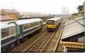
6
Sunderland to Newcastle Railway passing through Monkwearmouth Station Museum, Sunderland
Photographed on 16th September 2003 using an Olympus AF-10 Super (not sure about the type of film) and scanned using an Epson Perfection 2480 Photo. The weather was fine. Monkwearmouth Station Museum occupies the former Monkwearmouth Railway Station opened in 1848 and closed to passenger traffic in 1967. It became a museum in 1973 and is managed by Tyne and Wear Museums on behalf of the City of Sunderland. The railway from Sunderland to Newcastle passes by the site giving a good view of the trains that are constantly passing by much to the delight of visitors both young and old!!
Image: © Martin Routledge
Taken: 16 Sep 2003
0.09 miles
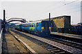
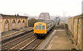
7
Trains passing at Monkwearmouth Station Museum, 6th April 1987
Image: © Martin Routledge
Taken: 6 Apr 1987
0.09 miles
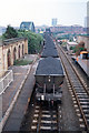
8
Train approaching the Wearmouth Rail Bridge, 1994.
Image: © Martin Routledge
Taken: Unknown
0.09 miles
9
Coal train approaching the Wearmouth Rail Bridge, Sunderland, 1994
Image: © Martin Routledge
Taken: Unknown
0.09 miles
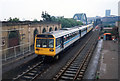
10
Train passing through Monkwearmouth Station Museum, 6th April 1987
Image: © Martin Routledge
Taken: 6 Apr 1987
0.09 miles