IMAGES TAKEN NEAR TO
Brockenhurst Drive, SUNDERLAND, SR4 9NS
Introduction
This page details the photographs taken nearby to Brockenhurst Drive, SR4 9NS by members of the Geograph project.
The Geograph project started in 2005 with the aim of publishing, organising and preserving representative images for every square kilometre of Great Britain, Ireland and the Isle of Man.

There are currently over 7.5m images from over14,400 individuals and you can help contribute to the project by visiting https://www.geograph.org.uk
Image Map
Images are licensed for reuse under creativecommons.org/licenses/by-sa/2.0
Notes
- Clicking on the map will re-center to the selected point.
- The higher the marker number, the further away the image location is from the centre of the postcode.
Image Listing (25 Images Found)
Images are licensed for reuse under creativecommons.org/licenses/by-sa/2.0
Image
Details
Distance
5
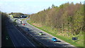
A19 trunk road near Sunderland
This view was taken from a bridge over the A19 trunk road, looking north towards its junction with the A183.
Image: © Malc McDonald
Taken: 19 Apr 2014
0.17 miles
6
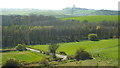
View from Hasting Hill, Sunderland
This view looks west from the trig point at Hasting Hill, near Sunderland. The Penshaw Monument is visible on a hill in the distance.
Image: © Malc McDonald
Taken: 19 Apr 2014
0.17 miles
7
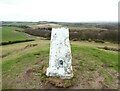
Triangulation Pillar, Hasting Hill
The triangulation pillar on the summit of Hasting Hill. The concrete pillar has been subjected to vandalism with large chunks of concrete removed from one corner.
The flush bracket benchmark number S4093 on the north face of the pillar marks a height of 124.709m above sea level (Ordnance Datum Newlyn) last verified in 1984.
Image: © Adrian Taylor
Taken: 25 Mar 2021
0.17 miles
8
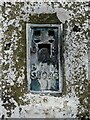
Flush Bracket, Hasting Hill
Detail of the flush bracket on the triangulation pillar on the summit of Hasting Hill. The flush bracket benchmark number S4093 is on the north-northeast face of the pillar and marks a height of 124.709m above sea level (Ordnance Datum Newlyn) last verified in 1984.
Image: © Adrian Taylor
Taken: 25 Mar 2021
0.17 miles
9
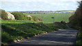
Foxcover Road, near Sunderland
The sign on the other side of the road indicates a public footpath.
Image: © Malc McDonald
Taken: 19 Apr 2014
0.17 miles
10
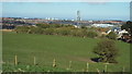
View over Sunderland
This view over the city of Sunderland was taken from Hasting Hill. The North Sea is just visible on the horizon.
Image: © Malc McDonald
Taken: 19 Apr 2014
0.17 miles