IMAGES TAKEN NEAR TO
Lynwood Avenue, SUNDERLAND, SR4 9NL
Introduction
This page details the photographs taken nearby to Lynwood Avenue, SR4 9NL by members of the Geograph project.
The Geograph project started in 2005 with the aim of publishing, organising and preserving representative images for every square kilometre of Great Britain, Ireland and the Isle of Man.

There are currently over 7.5m images from over14,400 individuals and you can help contribute to the project by visiting https://www.geograph.org.uk
Image Map
Images are licensed for reuse under creativecommons.org/licenses/by-sa/2.0
Notes
- Clicking on the map will re-center to the selected point.
- The higher the marker number, the further away the image location is from the centre of the postcode.
Image Listing (18 Images Found)
Images are licensed for reuse under creativecommons.org/licenses/by-sa/2.0
Image
Details
Distance

5
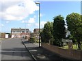
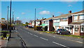
Sevenoaks Drive, Sunderland
On the opposite side of the road is a parade of local shops.
Image: © Malc McDonald
Taken: 19 Apr 2014
0.15 miles
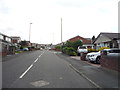
6
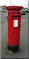
Elizabeth II postbox on Sevenoaks Drive, Sunderland
Postbox No. SR4 288.
See Image] for context.
Image: © JThomas
Taken: 18 Aug 2018
0.15 miles
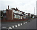
7
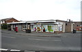
Nisa Local shop on Sevenoaks Drive, Sunderland
Showing position of Postbox No. SR4 288.
See Image] for postbox.
Image: © JThomas
Taken: 18 Aug 2018
0.15 miles
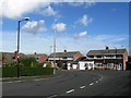
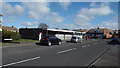
10
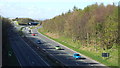
A19 trunk road near Sunderland
This view was taken from a bridge over the A19 trunk road, looking north towards its junction with the A183.
Image: © Malc McDonald
Taken: 19 Apr 2014
0.20 miles