IMAGES TAKEN NEAR TO
Coxgreen, SUNDERLAND, SR4 9JT
Introduction
This page details the photographs taken nearby to SR4 9JT by members of the Geograph project.
The Geograph project started in 2005 with the aim of publishing, organising and preserving representative images for every square kilometre of Great Britain, Ireland and the Isle of Man.

There are currently over 7.5m images from over14,400 individuals and you can help contribute to the project by visiting https://www.geograph.org.uk
Image Map
Images are licensed for reuse under creativecommons.org/licenses/by-sa/2.0
Notes
- Clicking on the map will re-center to the selected point.
- The higher the marker number, the further away the image location is from the centre of the postcode.
Image Listing (14 Images Found)
Images are licensed for reuse under creativecommons.org/licenses/by-sa/2.0
Image
Details
Distance
1
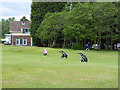
Three caddy carts at Wearside Golf Club
But no sign of the golfers. A picturesque and challenging course dating back to 1892.
Image: © Oliver Dixon
Taken: 19 Jun 2015
0.01 miles
2
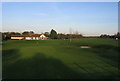
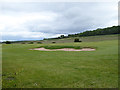
Wearside Golf Course, Clubhouse and first green
This Club was founded in 1892 and has a distinguished history.
Image: © Alan Fearon
Taken: 19 Nov 2005
0.03 miles
3
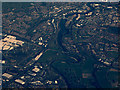
The River Wear from the air
Wearside Golf Course is in the foreground, the Northern Spire bridge https://en.wikipedia.org/wiki/Northern_Spire_Bridge is also prominent. Viewed from 37,000 feet.
Image: © Thomas Nugent
Taken: 28 Jan 2019
0.06 miles
4
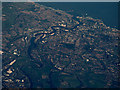
The River Wear from the air
Looking downstream from Wearside Golf Course to Sunderland and the North Sea. The Northern Spire bridge https://en.wikipedia.org/wiki/Northern_Spire_Bridge is prominent. Viewed from 37,000 feet.
Image: © Thomas Nugent
Taken: 28 Jan 2019
0.06 miles
5
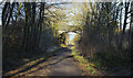
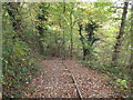
Route of Leamside Line passing beneath bridge
The Leamside Line was originally part of the Durham Junction Railway. Its use became progressively limited and was closed in the early 1990s but with the possibility of a reopening, the land over which it runs has been retained. At present, (early 2021), the stretch in view acts as a path and cycleway.
Image: © Trevor Littlewood
Taken: 18 Feb 2021
0.11 miles
6
A bunker on the Wearside Golf Club course
A picturesque and challenging course dating back to 1892. The wooded slopes to the right lie below Offerton village.
Image: © Oliver Dixon
Taken: 19 Jun 2015
0.15 miles
8
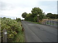
Coxgreen Road towards Offerton
Looking north east.
Image: © JThomas
Taken: 18 Aug 2018
0.19 miles
9
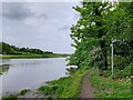
Steps on the Weardale Way near Washington
Steps on the Weardale Way long distance footpath, near Washington.
Image: © Malc McDonald
Taken: 29 Oct 2016
0.20 miles
10
Footpath junction on the Weardale Way
The path to the right leads up Penshaw Hill to the prominent Penshaw Monument
Image: © Tim Heaton
Taken: 18 May 2023
0.21 miles