IMAGES TAKEN NEAR TO
Railway Cottages, SUNDERLAND, SR4 9JR
Introduction
This page details the photographs taken nearby to Railway Cottages, SR4 9JR by members of the Geograph project.
The Geograph project started in 2005 with the aim of publishing, organising and preserving representative images for every square kilometre of Great Britain, Ireland and the Isle of Man.

There are currently over 7.5m images from over14,400 individuals and you can help contribute to the project by visiting https://www.geograph.org.uk
Image Map
Images are licensed for reuse under creativecommons.org/licenses/by-sa/2.0
Notes
- Clicking on the map will re-center to the selected point.
- The higher the marker number, the further away the image location is from the centre of the postcode.
Image Listing (14 Images Found)
Images are licensed for reuse under creativecommons.org/licenses/by-sa/2.0
Image
Details
Distance
1
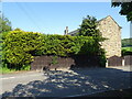
Cox Green railway station (site), Tyne & Wear
Opened in 1853 as "Coxgreen Halt" by the York Newcastle & Berwick Railway, soon to be part of the North Eastern Railway, on the line from Durham to Sunderland. It became "Coxgreen Crossing" in 1857 and "Coxgreen" in 1857, changing to "Cox Green" in 1931. It closed in 1964.
View north east towards Hylton and Sunderland from the site of the level crossing. There were two parallel platforms. The main building on the right has been extended as part of a private house.
Image: © Nigel Thompson
Taken: 29 May 2021
0.02 miles
2
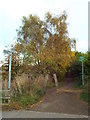
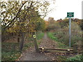
Bridleway on former railway at Cox Green, near Washington
This public bridleway follows the route of a dismantled railway line in Tyne & Wear.
Although it is hard to detect, there used to be a railway station here. More information about Cox Green station, with images, is on the Disused Stations site: http://www.disused-stations.org.uk/c/cox_green/
Image: © Malc McDonald
Taken: 29 Oct 2016
0.02 miles
3
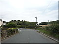
Road junction on Coxgreen Road
Looking north east.
Image: © JThomas
Taken: 18 Aug 2018
0.03 miles
4
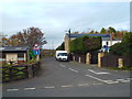
Lane at Cox Green, near Washington
The building just by the parked van is the former Cox Green station building. The station closed in 1964.
More information about Cox Green station can be found on the Disused Stations site: http://www.disused-stations.org.uk/c/cox_green/
Image: © Malc McDonald
Taken: 29 Oct 2016
0.03 miles
5
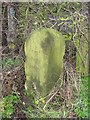
Old Boundary Marker by Cox Green Road, south of Washington
Boundary Marker by the UC road, in parish of Sunderland (Sunderland District), Cox Green Station, by fingerpost: DU_NZ3354 Image
Inscription reads:-
NEW
PENSHER
1867
Grade II listed: List Entry Number: 1184833
https://historicengland.org.uk/listing/the-list/list-entry/1184833
To be surveyed
Milestone Society National ID: DU_NPEN01bm.
Image: © Milestone Society
Taken: Unknown
0.03 miles
6
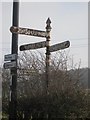
Old Direction Sign - Signpost by Cox Green Road, south of Washington
Cone in cup finial - 3 arms; by the UC road, in parish of Sunderland (Sunderland District), Cox Green Station, in hedge by pole. Adjacent to: DU_NPEN01bm Image
To be surveyed
Milestone Society National ID: DU_NZ3354
Image: © Milestone Society
Taken: Unknown
0.03 miles
7
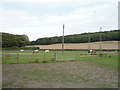
Grazing off Coxgreen Road
View towards Dawson's Plantation.
Image: © JThomas
Taken: 18 Aug 2018
0.03 miles
8
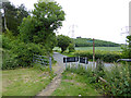
Coxgreen Road and Penshaw Monument
Access point on to the railway path from Sunderland to Penshaw.
Image: © Oliver Dixon
Taken: 19 Jun 2015
0.04 miles
9
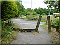
Cycle route crossing of the road down to Cox Green
The cycle route follows the line of the old railway from Sunderland to Penshaw. The wooden posts set at an angle are designed to stop motor bikes, but are also an obstacle to pedal cycles with long handlebars. The low rail adjoining is a horse stile which horses can step over but which also should prove a deterrent to motor bikes.
Image: © Oliver Dixon
Taken: 19 Jun 2015
0.04 miles
10
Bridleway on former railway at Cox Green, near Washington
This public bridleway follows the route of a dismantled railway in Tyne & Wear.
Image: © Malc McDonald
Taken: 29 Oct 2016
0.04 miles