IMAGES TAKEN NEAR TO
Offerton, SUNDERLAND, SR4 9JN
Introduction
This page details the photographs taken nearby to Offerton, SR4 9JN by members of the Geograph project.
The Geograph project started in 2005 with the aim of publishing, organising and preserving representative images for every square kilometre of Great Britain, Ireland and the Isle of Man.

There are currently over 7.5m images from over14,400 individuals and you can help contribute to the project by visiting https://www.geograph.org.uk
Image Map
Images are licensed for reuse under creativecommons.org/licenses/by-sa/2.0
Notes
- Clicking on the map will re-center to the selected point.
- The higher the marker number, the further away the image location is from the centre of the postcode.
Image Listing (4 Images Found)
Images are licensed for reuse under creativecommons.org/licenses/by-sa/2.0
Image
Details
Distance
1
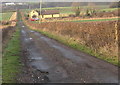
Railway Crossing Cottage Offerton Sunderland
Situated on the line of the former Painshaw Branch Line seen from the road from Offerton to the River Wear
Image: © Peter Robinson
Taken: 17 Jan 2010
0.00 miles
2
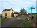
Cycle route and pedestrian path near South Hylton
This path, used by cyclists and pedestrians, follows the route of a dismantled railway line.
Image: © Malc McDonald
Taken: 29 Oct 2016
0.02 miles
3
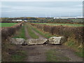
Public footpath near South Hylton
This track through farmland is also a public footpath.
The building in the background, to the right of the image, is part of the Nissan motor vehicle manufacturing plant on the outskirts of Sunderland.
Image: © Malc McDonald
Taken: 29 Oct 2016
0.03 miles
4
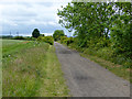
Railway path near Offerton
The former railway from Sunderland to Penshaw.
Image: © Oliver Dixon
Taken: 19 Jun 2015
0.10 miles