IMAGES TAKEN NEAR TO
Dumfries Close, SUNDERLAND, SR4 8RR
Introduction
This page details the photographs taken nearby to Dumfries Close, SR4 8RR by members of the Geograph project.
The Geograph project started in 2005 with the aim of publishing, organising and preserving representative images for every square kilometre of Great Britain, Ireland and the Isle of Man.

There are currently over 7.5m images from over14,400 individuals and you can help contribute to the project by visiting https://www.geograph.org.uk
Image Map
Images are licensed for reuse under creativecommons.org/licenses/by-sa/2.0
Notes
- Clicking on the map will re-center to the selected point.
- The higher the marker number, the further away the image location is from the centre of the postcode.
Image Listing (16 Images Found)
Images are licensed for reuse under creativecommons.org/licenses/by-sa/2.0
Image
Details
Distance
1
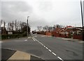
Road junction on Grindon Lane
Gleneagles Road coming in on the left. In the western suburbs of Sunderland.
Image: © Robert Graham
Taken: 15 Mar 2017
0.10 miles
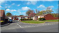
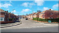
2
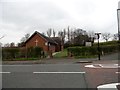
Methodist Church
On Gleneagles Road, beside the junction with Grindon Lane.
Image: © Robert Graham
Taken: 15 Mar 2017
0.12 miles
3
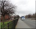
Bus on Grindon Lane
Viewed looking north. This is one of the new gas fuelled buses operated by Stagecoach around Sunderland.
Image: © Robert Graham
Taken: 15 Mar 2017
0.13 miles
4
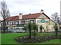
The Grindon Mill
In the Sunderland suburb of Grindon.
Image: © Chris Tweedy
Taken: 26 Jan 2006
0.14 miles
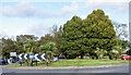
5
Roundabout on Chester Road, Sunderland
This is for the junction with Pennywell Road. Pennywell is the westernmost of a string of suburbs on the west side of the city, built in the post war era.
Image: © Robert Graham
Taken: 20 Feb 2018
0.15 miles
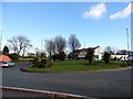
6
Glanton Square, Sunderland
Glanton Square is in Grindon, a suburb of Sunderland. In Grindon, all the street names begin with the letter "G".
Image: © Malc McDonald
Taken: 19 Apr 2014
0.15 miles
7
Roundabout along A183
The A183 at its junction with Pennywell Road which is on the far side of the roundabout.
Image: © Trevor Littlewood
Taken: 13 Oct 2023
0.15 miles
8
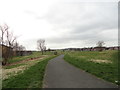
West end of Barnes Park
Looking west along this large public park beside the little Barnes Burn. This open area divides the two suburbs of Grindon and Thorney Close on the west side of Sunderland.
Image: © Robert Graham
Taken: 15 Mar 2017
0.19 miles
9
Galsworthy Road, Sunderland
Galsworthy Road, in Sunderland's suburbs. This street is in Grindon, an area where all the street names begin with the letter "G".
Image: © Malc McDonald
Taken: 19 Apr 2014
0.19 miles
10
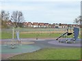
Play area at Springwell
In a green corridor along Barnes Burn. The single-storey building in the middle distance is St Cuthbert's RC Primary School. The houses of Sutherland Drive beyond.
Image: © Oliver Dixon
Taken: 15 Nov 2016
0.20 miles