IMAGES TAKEN NEAR TO
Killingworth Drive, SUNDERLAND, SR4 8QQ
Introduction
This page details the photographs taken nearby to Killingworth Drive, SR4 8QQ by members of the Geograph project.
The Geograph project started in 2005 with the aim of publishing, organising and preserving representative images for every square kilometre of Great Britain, Ireland and the Isle of Man.

There are currently over 7.5m images from over14,400 individuals and you can help contribute to the project by visiting https://www.geograph.org.uk
Image Map
Images are licensed for reuse under creativecommons.org/licenses/by-sa/2.0
Notes
- Clicking on the map will re-center to the selected point.
- The higher the marker number, the further away the image location is from the centre of the postcode.
Image Listing (10 Images Found)
Images are licensed for reuse under creativecommons.org/licenses/by-sa/2.0
Image
Details
Distance
1
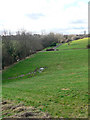
Barnes Park
The western end of Barnes Park in Sunderland.
Hidden by the trees is the Barnes Burn.
Image: © Chris Tweedy
Taken: 26 Jan 2006
0.11 miles
2
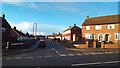
Beldene Drive, Sunderland
Suburban housing in the High Barnes area of Sunderland.
Image: © Malc McDonald
Taken: 22 Dec 2013
0.14 miles
4
Alley in Sunderland
An alley alongside housing in Sunderland.
Image: © Malc McDonald
Taken: 22 Dec 2013
0.16 miles
5
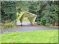
Barnes Park
A rather odd installation (reluctant to call it a sculpture) over a path where it crosses Barnes Burn.
Image: © Oliver Dixon
Taken: 15 Nov 2016
0.18 miles
6
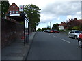
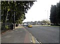
Bus stop and shelter on Ettrick Grove
Looking north.
Image: © JThomas
Taken: 28 May 2015
0.18 miles
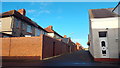
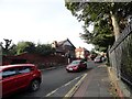
7
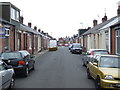
Kitchener Street, Sunderland
Kitchener Street, in the High Barnes area of Sunderland. The street is flanked by "Sunderland cottages" - these were built as terraces of single-storey homes for skilled workers. Some have had their lofts converted into extra bedrooms.
Image: © Malc McDonald
Taken: 27 Aug 2011
0.18 miles
8
North end of Westfield Grove
In the High Barnes area of Sunderland, south of The Broadway.
Image: © Robert Graham
Taken: 3 Oct 2016
0.21 miles
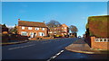
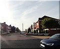
9
Looking east along The Broadway
One of the main routes west out of Sunderland city centre.
Image: © Robert Graham
Taken: 3 Oct 2016
0.24 miles
10
Looking west along Chester Road
In the High Barnes area of Sunderland. This is a major route west from the city centre.
Image: © Robert Graham
Taken: 3 Oct 2016
0.25 miles