IMAGES TAKEN NEAR TO
Gainsborough Road, SUNDERLAND, SR4 8HU
Introduction
This page details the photographs taken nearby to Gainsborough Road, SR4 8HU by members of the Geograph project.
The Geograph project started in 2005 with the aim of publishing, organising and preserving representative images for every square kilometre of Great Britain, Ireland and the Isle of Man.

There are currently over 7.5m images from over14,400 individuals and you can help contribute to the project by visiting https://www.geograph.org.uk
Image Map
Images are licensed for reuse under creativecommons.org/licenses/by-sa/2.0
Notes
- Clicking on the map will re-center to the selected point.
- The higher the marker number, the further away the image location is from the centre of the postcode.
Image Listing (23 Images Found)
Images are licensed for reuse under creativecommons.org/licenses/by-sa/2.0
Image
Details
Distance
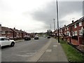
1
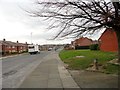
View west along Gleneagles Road
From close to the junction with Grindon Lane. This is one of the main roads through this large housing estate in the western suburbs of Sunderland.
Image: © Robert Graham
Taken: 15 Mar 2017
0.04 miles
2
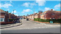
Galsworthy Road, Sunderland
Galsworthy Road, in Sunderland's suburbs. This street is in Grindon, an area where all the street names begin with the letter "G".
Image: © Malc McDonald
Taken: 19 Apr 2014
0.05 miles
3
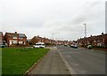
View east along Gleneagles Road
Part of a large housing estate in Grindon, a suburb of Sunderland.
Image: © Robert Graham
Taken: 15 Mar 2017
0.07 miles
4
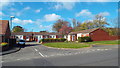
Glanton Square, Sunderland
Glanton Square is in Grindon, a suburb of Sunderland. In Grindon, all the street names begin with the letter "G".
Image: © Malc McDonald
Taken: 19 Apr 2014
0.09 miles
5
Looking west along Gleneagles Road
This is one of the main roads through the large housing estate at Grindon, one of the western suburbs of Sunderland.
Image: © Robert Graham
Taken: 15 Mar 2017
0.10 miles
6
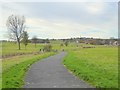
Cycle and foot-path at Grindon
Traversing a large area of open land which rises to Grindon Hill Image on the skyline. The Sunderland suburb of Grindon is off to the right.
Image: © Oliver Dixon
Taken: 15 Nov 2016
0.10 miles
7
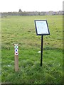
"Active Sunderland"
Path circuits across this large open space on the edge of Grindon are signed as part of the "Active Sunerland" scheme - green for 1 km, blue for 2 km and red for 3 km.
Image: © Oliver Dixon
Taken: 15 Nov 2016
0.11 miles
8
Parkland between Grindon and Thorney Close
Looking across parkland between Grindon and Thorney Close towards the local school
Image: © Graham Scarborough
Taken: 14 Jul 2007
0.12 miles
9
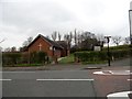
Methodist Church
On Gleneagles Road, beside the junction with Grindon Lane.
Image: © Robert Graham
Taken: 15 Mar 2017
0.12 miles
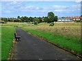
10
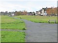
Foot- and cycle-path at Grindon
Traversing the edge of a large area of open land. The backs of houses on Gainsborough Road to the right.
Image: © Oliver Dixon
Taken: 15 Nov 2016
0.13 miles