IMAGES TAKEN NEAR TO
Holborn Road, SUNDERLAND, SR4 8AR
Introduction
This page details the photographs taken nearby to Holborn Road, SR4 8AR by members of the Geograph project.
The Geograph project started in 2005 with the aim of publishing, organising and preserving representative images for every square kilometre of Great Britain, Ireland and the Isle of Man.

There are currently over 7.5m images from over14,400 individuals and you can help contribute to the project by visiting https://www.geograph.org.uk
Image Map
Images are licensed for reuse under creativecommons.org/licenses/by-sa/2.0
Notes
- Clicking on the map will re-center to the selected point.
- The higher the marker number, the further away the image location is from the centre of the postcode.
Image Listing (10 Images Found)
Images are licensed for reuse under creativecommons.org/licenses/by-sa/2.0
Image
Details
Distance
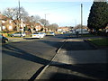
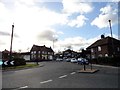
2
Roundabout and the 'Round Robin' pub.
Roundabout on a suburban road.
Image: © Brian Abbott
Taken: 12 May 2006
0.13 miles
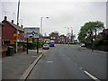
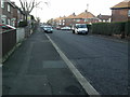
5
Suburban road junction
This at the south end of Front Road at the junction with Hylton Road, in the Ford Estate area. Part of the huge sprawl of western suburbs of Sunderland, built from the 1950's onwards.
Image: © Robert Graham
Taken: 20 Feb 2018
0.19 miles
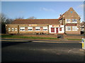
7
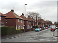
Hadleigh Road, Sunderland
Brick-built semi-detached houses along Hadleigh Road in the suburbs of Sunderland.
Image: © Malc McDonald
Taken: 27 Oct 2018
0.22 miles
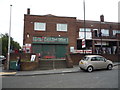
9
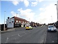
Local shops on Front Road
In the Ford area, in the western suburbs of Sunderland.
Image: © Robert Graham
Taken: 20 Feb 2018
0.24 miles
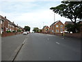
10
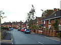
Friar Road, Sunderland
Friar Road is a residential road in the suburbs of Sunderland.
Image: © Malc McDonald
Taken: 27 Oct 2018
0.25 miles