IMAGES TAKEN NEAR TO
Kayll Road, SUNDERLAND, SR4 7TW
Introduction
This page details the photographs taken nearby to Kayll Road, SR4 7TW by members of the Geograph project.
The Geograph project started in 2005 with the aim of publishing, organising and preserving representative images for every square kilometre of Great Britain, Ireland and the Isle of Man.

There are currently over 7.5m images from over14,400 individuals and you can help contribute to the project by visiting https://www.geograph.org.uk
Image Map
Images are licensed for reuse under creativecommons.org/licenses/by-sa/2.0
Notes
- Clicking on the map will re-center to the selected point.
- The higher the marker number, the further away the image location is from the centre of the postcode.
Image Listing (32 Images Found)
Images are licensed for reuse under creativecommons.org/licenses/by-sa/2.0
Image
Details
Distance
1
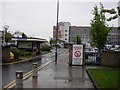
Main Entrance to Sunderland Royal Hospital
No smoking allowed anywhere in the hospital grounds!
Image: © Brian Abbott
Taken: 14 May 2006
0.06 miles
2
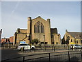
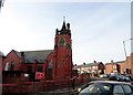
St Gabriel's Church, Chester Road
Pictured looking north across Chester Road. This is the parish church of Bishopwearmouth, designed in 1912 by C A Clayton Greene in Art Nouveau style.
Image: © Robert Graham
Taken: 3 Oct 2016
0.07 miles
4
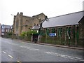
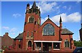
St Gabriels Church and Church Hall
Saint Gabriel’s Church is a Grade II listed structure built between 1909 and 1912 to the design of local architect, Clayton Greene. Still very active. Church hall ('community outreach centre') is to the right.
Image: © Brian Abbott
Taken: 14 May 2006
0.13 miles
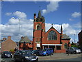
5
Ewesley Road Methodist Church
At the junction of Ewesley Road with Chester Road.
Image: © Robert Graham
Taken: 3 Oct 2016
0.13 miles
6
Ewesley Road Methodist Church
Ewesley Road Methodist Church in Sunderland.
Image: © Colin Kinnear
Taken: 19 Jul 2015
0.13 miles
7
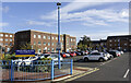
Car park at Chester Wing of Sunderland Royal Hospital
The Chester Wing of the hospital is where out-patients are seen; the car park is the most convenient for their use.
The brick-built building beyond the car park is the headquarters of the South Tyneside and Sunderland NHS Foundation Trust.
Image: © Trevor Littlewood
Taken: 13 Oct 2023
0.14 miles
8
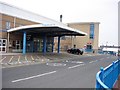
Outpatient Entrance to Sunderland Royal Hospital
The hospital covers much of this grid square. Lots of money has been spent here in recent years but as of the date of this picture they have a bit of a reputation for lack of cleanliness.
Image: © Brian Abbott
Taken: 12 May 2006
0.15 miles
9
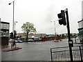
Crossroads on Hylton Road, Sunderland
Hylton Road is running from left to right on the picture, at the junction with Kayll Road. The Royal Hospital is in the background.
Image: © Robert Graham
Taken: 19 May 2017
0.15 miles
10
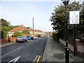
Priory Grove, High Barnes
Suburban housing on the western side of Sunderland City Centre. Leading north off Chester Road.
Image: © Robert Graham
Taken: 3 Oct 2016
0.16 miles