IMAGES TAKEN NEAR TO
Colchester Terrace, SUNDERLAND, SR4 7QE
Introduction
This page details the photographs taken nearby to Colchester Terrace, SR4 7QE by members of the Geograph project.
The Geograph project started in 2005 with the aim of publishing, organising and preserving representative images for every square kilometre of Great Britain, Ireland and the Isle of Man.

There are currently over 7.5m images from over14,400 individuals and you can help contribute to the project by visiting https://www.geograph.org.uk
Image Map
Images are licensed for reuse under creativecommons.org/licenses/by-sa/2.0
Notes
- Clicking on the map will re-center to the selected point.
- The higher the marker number, the further away the image location is from the centre of the postcode.
Image Listing (15 Images Found)
Images are licensed for reuse under creativecommons.org/licenses/by-sa/2.0
Image
Details
Distance
1
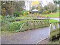
Bandstand in Barnes Park
In the foreground, a footbridge crosses Barnes Burn.
Image: © Oliver Dixon
Taken: 15 Nov 2016
0.14 miles
2
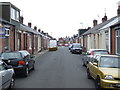
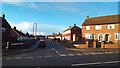
Kitchener Street, Sunderland
Kitchener Street, in the High Barnes area of Sunderland. The street is flanked by "Sunderland cottages" - these were built as terraces of single-storey homes for skilled workers. Some have had their lofts converted into extra bedrooms.
Image: © Malc McDonald
Taken: 27 Aug 2011
0.16 miles
3
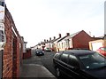
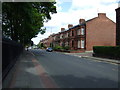
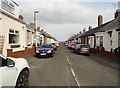
Sunderland cottages on Dunbar Street
This street which runs south from Chester Road consists of a good example of the Sunderland Cottages. These single storey terraced houses in long streets are a very distinctive style of housing in Sunderland. Numerous examples were built around the city from the mid C19 to the 1930's. They were a cost effective way to house the expanding population working in the shipyards and the mines. Mostly occupied by the more skilled workers, there was a high percentage of owner occupancy from the start.
Image: © Robert Graham
Taken: 3 Oct 2016
0.18 miles
4
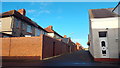
Alley in Sunderland
An alley alongside housing in Sunderland.
Image: © Malc McDonald
Taken: 22 Dec 2013
0.18 miles
6
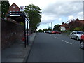
Bus stop and shelter on Ettrick Grove
Looking north.
Image: © JThomas
Taken: 28 May 2015
0.21 miles
7
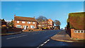
Beldene Drive, Sunderland
Suburban housing in the High Barnes area of Sunderland.
Image: © Malc McDonald
Taken: 22 Dec 2013
0.21 miles
9
Hawarden Crescent, Sunderland
A fine example of a street of "Sunderland cottages". Hundreds of these single storey terraced cottages were built in the city in the C19 and early C20. They form a distinctive local type little used elsewhere.
Image: © Robert Graham
Taken: 15 Mar 2017
0.23 miles
10
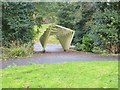
Barnes Park
A rather odd installation (reluctant to call it a sculpture) over a path where it crosses Barnes Burn.
Image: © Oliver Dixon
Taken: 15 Nov 2016
0.24 miles