IMAGES TAKEN NEAR TO
Hurstwood Road, SUNDERLAND, SR4 7LJ
Introduction
This page details the photographs taken nearby to Hurstwood Road, SR4 7LJ by members of the Geograph project.
The Geograph project started in 2005 with the aim of publishing, organising and preserving representative images for every square kilometre of Great Britain, Ireland and the Isle of Man.

There are currently over 7.5m images from over14,400 individuals and you can help contribute to the project by visiting https://www.geograph.org.uk
Image Map
Images are licensed for reuse under creativecommons.org/licenses/by-sa/2.0
Notes
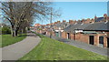
- Clicking on the map will re-center to the selected point.
- The higher the marker number, the further away the image location is from the centre of the postcode.
Image Listing (16 Images Found)
Images are licensed for reuse under creativecommons.org/licenses/by-sa/2.0
Image
Details
Distance
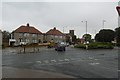
1
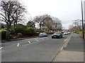
Barnes Park Road
West end of Sunderland. View looking north.
Image: © Robert Graham
Taken: 15 Mar 2017
0.10 miles
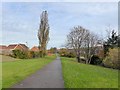
2
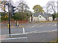
Crossing on Barnes Park Road
A signed cycle route follows the course of the Barnes Brook. Here it crosses Barnes Park Road before entering Barnes Park by the Coach House cafe.
Image: © Oliver Dixon
Taken: 15 Nov 2016
0.11 miles
3
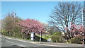
Cycle route NCN1 in Sunderland
The path in the centre of the image forms part of National Cycle Network route 1 (NCN1), a long-distance cycle route from Dover to the Shetland islands up the eastern side of Britain. The path follows the route of a former railway into Sunderland.
This image was taken in April, while trees were in blossom.
Image: © Malc McDonald
Taken: 19 Apr 2014
0.14 miles
5
Cycle- and foot-path in Sunderland
Following a green corridor along the line of the former Hetton Colliery Railway.
Image: © Oliver Dixon
Taken: 15 Nov 2016
0.16 miles
6
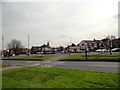
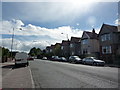
Junction of Queen Alexander Road with Durham Road
On the west side of Sunderland. Durham Road is the A690, the main SW route out of the city centre.
Image: © Robert Graham
Taken: 15 Mar 2017
0.16 miles
8
Ranson Street, Sunderland
Ranson Street is a residential street leading off Durham Road in Sunderland.
Image: © Malc McDonald
Taken: 19 Apr 2014
0.18 miles
9
Path past backyards, Sunderland
This raised path follows the route of a former railway into Sunderland. The path forms part of the National Cycle Network route 1, a long distance route linking Dover with the Shetland Islands.
Image: © Malc McDonald
Taken: 19 Apr 2014
0.20 miles
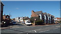
10
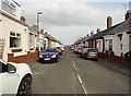
Hawarden Crescent, Sunderland
A fine example of a street of "Sunderland cottages". Hundreds of these single storey terraced cottages were built in the city in the C19 and early C20. They form a distinctive local type little used elsewhere.
Image: © Robert Graham
Taken: 15 Mar 2017
0.20 miles