IMAGES TAKEN NEAR TO
Florida Street, SUNDERLAND, SR4 6TE
Introduction
This page details the photographs taken nearby to Florida Street, SR4 6TE by members of the Geograph project.
The Geograph project started in 2005 with the aim of publishing, organising and preserving representative images for every square kilometre of Great Britain, Ireland and the Isle of Man.

There are currently over 7.5m images from over14,400 individuals and you can help contribute to the project by visiting https://www.geograph.org.uk
Image Map
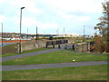
Images are licensed for reuse under creativecommons.org/licenses/by-sa/2.0
Notes
- Clicking on the map will re-center to the selected point.
- The higher the marker number, the further away the image location is from the centre of the postcode.
Image Listing (37 Images Found)
Images are licensed for reuse under creativecommons.org/licenses/by-sa/2.0
Image
Details
Distance
1
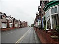
Looking north along Merle Terrace
In the Pallion district of Sunderland. These terraces are probably Victorian in date.
Image: © Robert Graham
Taken: 19 May 2017
0.07 miles
2

Florida Street, Pallion Sunderland, 23 March 2006
Image: © Martin Routledge
Taken: 23 Mar 2006
0.08 miles
3
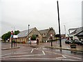
View of Merle Terrace Sunderland
Looking north to St Luke's church from the cross roads with Neville Road.
Image: © Robert Graham
Taken: 19 May 2017
0.10 miles
4
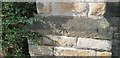
Ordnance Survey Cut Mark
This OS cut mark can be found on the east face of St Luke's Church. It marks a point 35.128m above mean sea level.
Image: © Adrian Dust
Taken: 20 Sep 2018
0.10 miles
6
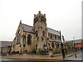
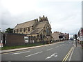
St Luke's church, Sunderland
Large Victorian church on Merle Terrace in the Pallion district. Dates from 1874 by J S Pritchett.
Image: © Robert Graham
Taken: 19 May 2017
0.10 miles
7
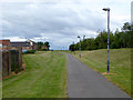
Cycle path at Pallion
This cycle path runs close to the Tyne and Wear Metro extension from Sunderland to South Hylton, opened in 2002 which makes use in the main of the line of the former Sunderland to Durham railway.
Image: © Oliver Dixon
Taken: 19 Jun 2015
0.13 miles
8
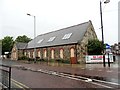
St Luke's church hall, Sunderland
On Merle Terrace in the Pallion district, west of the city centre.
Image: © Robert Graham
Taken: 19 May 2017
0.13 miles
9
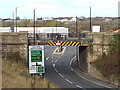
Former railway bridge at Pallion, Sunderland
This bridge used to carry a railway line across the road. The railway has been dismantled, its route is now occupied by a path for pedestrians and cyclists.
Image: © Malc McDonald
Taken: 27 Oct 2018
0.13 miles
10
Former railway path at Pallion, Sunderland
A path for pedestrians and cyclists along the route of a former railway. Here, the path uses a former railway bridge to cross a road.
The path forms part of the Tyne & Wear Heritage Way as well as the Weardale Way.
Image: © Malc McDonald
Taken: 27 Oct 2018
0.13 miles