IMAGES TAKEN NEAR TO
Lyndhurst Terrace, SUNDERLAND, SR4 6SQ
Introduction
This page details the photographs taken nearby to Lyndhurst Terrace, SR4 6SQ by members of the Geograph project.
The Geograph project started in 2005 with the aim of publishing, organising and preserving representative images for every square kilometre of Great Britain, Ireland and the Isle of Man.

There are currently over 7.5m images from over14,400 individuals and you can help contribute to the project by visiting https://www.geograph.org.uk
Image Map
Images are licensed for reuse under creativecommons.org/licenses/by-sa/2.0
Notes
- Clicking on the map will re-center to the selected point.
- The higher the marker number, the further away the image location is from the centre of the postcode.
Image Listing (40 Images Found)
Images are licensed for reuse under creativecommons.org/licenses/by-sa/2.0
Image
Details
Distance
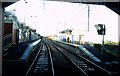
1
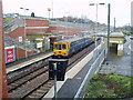
Pallion Metro Station, Sunderland
Photographed on 28th January 2006 using an Olympus 400 Digital. The weather was overcast but dry.
Image: © Martin Routledge
Taken: 28 Jan 2006
0.03 miles
2

Pallion Metro Station, Sunderland
Photographed on 28th January 2006 using an Olympus 400 Digital. The weather was overcast but dry.
Image: © Martin Routledge
Taken: 28 Jan 2006
0.03 miles
3
Site of old railway station and line, Pallion, now part of the Coast to Coast cycle route, 28th January 2006.
Image: © Martin Routledge
Taken: 28 Jan 2006
0.03 miles
4
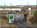
Pallion railway station (site), Tyne & Wear
Opened in 1853 by the York Newcastle & Berwick Railway, soon to be part of the North Eastern Railway, on the line from Durham to Sunderland, this station closed to passengers in 1964 and completely in 1965.
View west towards South Hylton and Durham. The station was beyond the bridge. The whole area has since been landscaped. When the Metro line was reopened to South Hylton, a more northerly route was chosen with Pallion Metro station being around 100m to the right, down the hill (see Image).
For more information, see http://www.disused-stations.org.uk/p/pallion_first/index.shtml
Image: © Nigel Thompson
Taken: 24 Mar 2012
0.05 miles
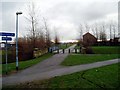
5
Former railway path at Pallion, Sunderland
A path for pedestrians and cyclists along the route of a former railway. Here, the path uses a former railway bridge to cross a road.
The path forms part of the Tyne & Wear Heritage Way as well as the Weardale Way.
Image: © Malc McDonald
Taken: 27 Oct 2018
0.05 miles
6
Former railway bridge at Pallion, Sunderland
This bridge used to carry a railway line across the road. The railway has been dismantled, its route is now occupied by a path for pedestrians and cyclists.
Image: © Malc McDonald
Taken: 27 Oct 2018
0.05 miles
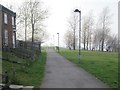
7
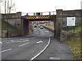
Former railway bridge at Pallion, Sunderland
A former railway bridge at Pallion, in Sunderland. The railway route has been converted into a pedestrian and cycle path.
Image: © Malc McDonald
Taken: 27 Oct 2018
0.06 miles
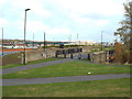
9
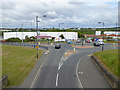
Roundabout by Pallion Metro Station
The Tyne and Wear Metro was extended from Sunderland to South Hylton in 2002 making use in the main of the line of the former Sunderland to Durham railway. Pallion Station itself is almost hidden behind the bushes to the left beyond Pallion New Road. In the foreground is Pallion Subway.
Image: © Oliver Dixon
Taken: 19 Jun 2015
0.08 miles
10
Entering Pallion Metro Station, 16th February 2006.
Image: © Martin Routledge
Taken: 16 Feb 2006
0.09 miles