IMAGES TAKEN NEAR TO
Exeter Street, SUNDERLAND, SR4 6QX
Introduction
This page details the photographs taken nearby to Exeter Street, SR4 6QX by members of the Geograph project.
The Geograph project started in 2005 with the aim of publishing, organising and preserving representative images for every square kilometre of Great Britain, Ireland and the Isle of Man.

There are currently over 7.5m images from over14,400 individuals and you can help contribute to the project by visiting https://www.geograph.org.uk
Image Map
Images are licensed for reuse under creativecommons.org/licenses/by-sa/2.0
Notes
- Clicking on the map will re-center to the selected point.
- The higher the marker number, the further away the image location is from the centre of the postcode.
Image Listing (35 Images Found)
Images are licensed for reuse under creativecommons.org/licenses/by-sa/2.0
Image
Details
Distance
1
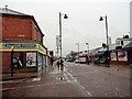
Shops on St Luke's Terrace, Sunderland
Looking north at the junction with Midmoor Road. West side of the city.
Image: © Robert Graham
Taken: 19 May 2017
0.02 miles
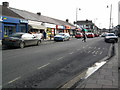
2
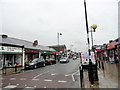
View along St Luke's Terrace, Sunderland
Looking north along this local shopping street in the Pallion district of the city.
Image: © Robert Graham
Taken: 19 May 2017
0.02 miles
3
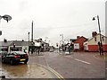
Looking south down St Luke's Terrace
Pallion district of Sunderland. At the junction with Neville Road.
Image: © Robert Graham
Taken: 19 May 2017
0.02 miles
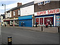
4
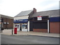
Shops on St Luke's Terrace, Sunderland
Showing position of Postbox No. SR4 41.
See Image] for postbox.
Image: © JThomas
Taken: 18 Aug 2018
0.03 miles
5
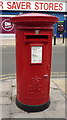
Elizabeth II postbox on St Luke's Terrace, Sunderland
Postbox No. SR4 41.
See Image] for context.
Image: © JThomas
Taken: 18 Aug 2018
0.03 miles
6
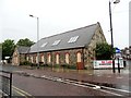
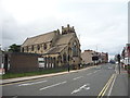
St Luke's church hall, Sunderland
On Merle Terrace in the Pallion district, west of the city centre.
Image: © Robert Graham
Taken: 19 May 2017
0.03 miles
10
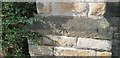
Ordnance Survey Cut Mark
This OS cut mark can be found on the east face of St Luke's Church. It marks a point 35.128m above mean sea level.
Image: © Adrian Dust
Taken: 20 Sep 2018
0.06 miles