IMAGES TAKEN NEAR TO
Oxford Street, SUNDERLAND, SR4 6PH
Introduction
This page details the photographs taken nearby to Oxford Street, SR4 6PH by members of the Geograph project.
The Geograph project started in 2005 with the aim of publishing, organising and preserving representative images for every square kilometre of Great Britain, Ireland and the Isle of Man.

There are currently over 7.5m images from over14,400 individuals and you can help contribute to the project by visiting https://www.geograph.org.uk
Image Map
Images are licensed for reuse under creativecommons.org/licenses/by-sa/2.0
Notes
- Clicking on the map will re-center to the selected point.
- The higher the marker number, the further away the image location is from the centre of the postcode.
Image Listing (7 Images Found)
Images are licensed for reuse under creativecommons.org/licenses/by-sa/2.0
Image
Details
Distance
1
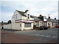
Lucky Garden
Chinese takeaway on Plantation Road.
Image: © JThomas
Taken: 18 Aug 2018
0.07 miles
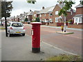
2
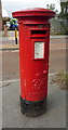
George VI postbox on St Luke's Road, Sunderland
Postbox No. SR4 186.
See Image] for context.
Image: © JThomas
Taken: 18 Aug 2018
0.07 miles
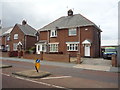
3
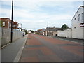
Houses on St Luke's Road, Sunderland
Showing position of Postbox No. SR4 186.
See Image] for postbox.
Image: © JThomas
Taken: 18 Aug 2018
0.07 miles
6
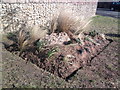
Flower Bed
Created recently on Saint Lukes Road
Image: © Gary Fellows
Taken: 23 Feb 2015
0.10 miles
7
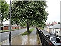
Street tree on Fordfield Road
In the western suburbs of Sunderland. Looking west from near the junction with Pallion Road.
Image: © Robert Graham
Taken: 19 May 2017
0.23 miles