IMAGES TAKEN NEAR TO
East Way, Rivergreen Industrial Estate, SUNDERLAND, SR4 6AD
Introduction
This page details the photographs taken nearby to East Way, Rivergreen Industrial Estate, SR4 6AD by members of the Geograph project.
The Geograph project started in 2005 with the aim of publishing, organising and preserving representative images for every square kilometre of Great Britain, Ireland and the Isle of Man.

There are currently over 7.5m images from over14,400 individuals and you can help contribute to the project by visiting https://www.geograph.org.uk
Image Map
Images are licensed for reuse under creativecommons.org/licenses/by-sa/2.0
Notes
- Clicking on the map will re-center to the selected point.
- The higher the marker number, the further away the image location is from the centre of the postcode.
Image Listing (40 Images Found)
Images are licensed for reuse under creativecommons.org/licenses/by-sa/2.0
Image
Details
Distance
1
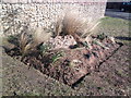
Flower Bed
Created recently on Saint Lukes Road
Image: © Gary Fellows
Taken: 23 Feb 2015
0.10 miles
3

Pallion Metro Station, Sunderland
Photographed on 28th January 2006 using an Olympus 400 Digital. The weather was overcast but dry.
Image: © Martin Routledge
Taken: 28 Jan 2006
0.11 miles
4
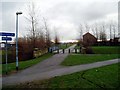
Site of old railway station and line, Pallion, now part of the Coast to Coast cycle route, 28th January 2006.
Image: © Martin Routledge
Taken: 28 Jan 2006
0.11 miles
5
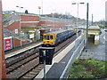
Pallion Metro Station, Sunderland
Photographed on 28th January 2006 using an Olympus 400 Digital. The weather was overcast but dry.
Image: © Martin Routledge
Taken: 28 Jan 2006
0.11 miles
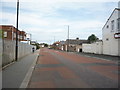
6
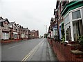
Looking north along Merle Terrace
In the Pallion district of Sunderland. These terraces are probably Victorian in date.
Image: © Robert Graham
Taken: 19 May 2017
0.12 miles
7
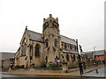
St Luke's church, Sunderland
Large Victorian church on Merle Terrace in the Pallion district. Dates from 1874 by J S Pritchett.
Image: © Robert Graham
Taken: 19 May 2017
0.12 miles
8
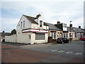
Lucky Garden
Chinese takeaway on Plantation Road.
Image: © JThomas
Taken: 18 Aug 2018
0.12 miles
9
View of Merle Terrace Sunderland
Looking north to St Luke's church from the cross roads with Neville Road.
Image: © Robert Graham
Taken: 19 May 2017
0.13 miles
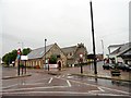
10
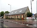
St Luke's church hall, Sunderland
On Merle Terrace in the Pallion district, west of the city centre.
Image: © Robert Graham
Taken: 19 May 2017
0.13 miles