IMAGES TAKEN NEAR TO
Wear View, SUNDERLAND, SR4 0RF
Introduction
This page details the photographs taken nearby to Wear View, SR4 0RF by members of the Geograph project.
The Geograph project started in 2005 with the aim of publishing, organising and preserving representative images for every square kilometre of Great Britain, Ireland and the Isle of Man.

There are currently over 7.5m images from over14,400 individuals and you can help contribute to the project by visiting https://www.geograph.org.uk
Image Map
Images are licensed for reuse under creativecommons.org/licenses/by-sa/2.0
Notes
- Clicking on the map will re-center to the selected point.
- The higher the marker number, the further away the image location is from the centre of the postcode.
Image Listing (15 Images Found)
Images are licensed for reuse under creativecommons.org/licenses/by-sa/2.0
Image
Details
Distance
1
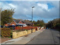
Riverside Park, South Hylton
Riverside Park is a residential cul-de-sac in South Hylton, on the outskirts of Sunderland.
In the background, the Northern Spire bridge peeps over the trees.
Image: © Malc McDonald
Taken: 27 Oct 2018
0.14 miles
2
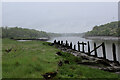
River Wear at North Hylton looking Downstream
A rather murky scene, endorsed by the soft mudbanks - rich in nutrients and other unmentionable items.
Rotting jetty posts add to the rather desolate surroundings of gradual decay.
Image: © Chris Heaton
Taken: 19 May 2023
0.15 miles
4
River Wear at North Hylton looking Upstream
A rather murky scene, endorsed by the soft mudbanks - rich in nutrients and other unmentionable items.
Rotting jetty posts add to the rather desolate surroundings of gradual decay.
Image: © Chris Heaton
Taken: 19 May 2023
0.16 miles
5
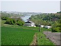
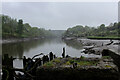
River Wear with Sunderland in the background
Farmland and river on the western outskirts of Sunderland.
Image: © Brian Abbott
Taken: 10 May 2006
0.17 miles
6

The Church of St Mary, South Hylton
Image: © Alexander P Kapp
Taken: 25 May 2011
0.18 miles
7
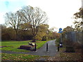
Path near South Hylton
A shared use path near South Hylton, on the outskirts of Sunderland.
Image: © Malc McDonald
Taken: 27 Oct 2018
0.18 miles
8

The Church of St Mary, South Hylton, Doorway
Image: © Alexander P Kapp
Taken: 25 May 2011
0.20 miles
9

The Church of St Mary, South Hylton
Image: © Alexander P Kapp
Taken: 25 May 2011
0.20 miles
10

Ordnance Survey Cut Mark
This OS cut mark can be found on the SW face of St Mary's Church. It marks a point 28.801m above mean sea level.
Image: © Adrian Dust
Taken: 20 Sep 2018
0.20 miles