IMAGES TAKEN NEAR TO
Lilac Street, SUNDERLAND, SR4 0PN
Introduction
This page details the photographs taken nearby to Lilac Street, SR4 0PN by members of the Geograph project.
The Geograph project started in 2005 with the aim of publishing, organising and preserving representative images for every square kilometre of Great Britain, Ireland and the Isle of Man.

There are currently over 7.5m images from over14,400 individuals and you can help contribute to the project by visiting https://www.geograph.org.uk
Image Map
Images are licensed for reuse under creativecommons.org/licenses/by-sa/2.0
Notes
- Clicking on the map will re-center to the selected point.
- The higher the marker number, the further away the image location is from the centre of the postcode.
Image Listing (46 Images Found)
Images are licensed for reuse under creativecommons.org/licenses/by-sa/2.0
Image
Details
Distance
1

The Jolly Potter, High Street, South Hylton
Image: © Alexander P Kapp
Taken: 25 May 2011
0.07 miles
2

Ordnance Survey Cut Mark
This OS cut mark can be found on the SW face of St Mary's Church. It marks a point 28.801m above mean sea level.
Image: © Adrian Dust
Taken: 20 Sep 2018
0.12 miles
3

The Church of St Mary, South Hylton
Image: © Alexander P Kapp
Taken: 25 May 2011
0.12 miles
4

The Church of St Mary, South Hylton, Doorway
Image: © Alexander P Kapp
Taken: 25 May 2011
0.12 miles
5
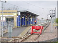
South Hylton Metro Station, Sunderland, 1st May 2006
Image: © Martin Routledge
Taken: 1 May 2006
0.13 miles
6
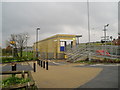
South Hylton Metro Station, Sunderland, 1st May 2006
Image: © Martin Routledge
Taken: 1 May 2006
0.13 miles
7
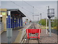
South Hylton Metro Station, Sunderland, 1st May 2006
Image: © Martin Routledge
Taken: 1 May 2006
0.13 miles
8
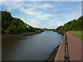
River Wear
North of the Golden Lion
Image: © Alexander P Kapp
Taken: 25 May 2011
0.13 miles
9
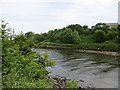
River Wear, Hylton
Between North and South Hylton.
Image: © Richard Webb
Taken: 18 Jun 2013
0.13 miles
10

The Church of St Mary, South Hylton
Image: © Alexander P Kapp
Taken: 25 May 2011
0.13 miles