IMAGES TAKEN NEAR TO
Primrose Street, SUNDERLAND, SR4 0PH
Introduction
This page details the photographs taken nearby to Primrose Street, SR4 0PH by members of the Geograph project.
The Geograph project started in 2005 with the aim of publishing, organising and preserving representative images for every square kilometre of Great Britain, Ireland and the Isle of Man.

There are currently over 7.5m images from over14,400 individuals and you can help contribute to the project by visiting https://www.geograph.org.uk
Image Map
Images are licensed for reuse under creativecommons.org/licenses/by-sa/2.0
Notes
- Clicking on the map will re-center to the selected point.
- The higher the marker number, the further away the image location is from the centre of the postcode.
Image Listing (44 Images Found)
Images are licensed for reuse under creativecommons.org/licenses/by-sa/2.0
Image
Details
Distance
1

The Jolly Potter, High Street, South Hylton
Image: © Alexander P Kapp
Taken: 25 May 2011
0.07 miles
2
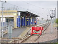
South Hylton Metro Station, Sunderland, 1st May 2006
Image: © Martin Routledge
Taken: 1 May 2006
0.12 miles
3
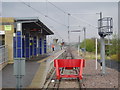
South Hylton Metro Station, Sunderland, 1st May 2006
Image: © Martin Routledge
Taken: 1 May 2006
0.12 miles
4
South Hylton Metro Station, Sunderland, 1st May 2006
Image: © Martin Routledge
Taken: 1 May 2006
0.12 miles
5

The Church of St Mary, South Hylton, Doorway
Image: © Alexander P Kapp
Taken: 25 May 2011
0.12 miles
6

The Church of St Mary, South Hylton
Image: © Alexander P Kapp
Taken: 25 May 2011
0.12 miles
7

Ordnance Survey Cut Mark
This OS cut mark can be found on the SW face of St Mary's Church. It marks a point 28.801m above mean sea level.
Image: © Adrian Dust
Taken: 20 Sep 2018
0.12 miles
8

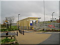
Ford Crescent
An attractive green square adjacent to South Hylton Metro Station.
Image: © Oliver Dixon
Taken: 19 Jun 2015
0.12 miles
9

The Church of St Mary, South Hylton
Image: © Alexander P Kapp
Taken: 25 May 2011
0.14 miles
10

Hylton railway station (site), Tyne & Wear
Opened in 1853 by the York Newcastle & Berwick Railway, later part of the North Eastern Railway, on the line from Durham to Sunderland, this station closed to passengers in 1964 and completely in 1965.
View south west towards Cox Green and Durham from the site of the level crossing. The main building was to the right, a signal box stood far left. Behind the camera position is the terminus of the Tyne & Wear Metro, now called South Hylton. See Image
For more information, see http://www.disused-stations.org.uk/h/hylton/index.shtml
Image: © Nigel Thompson
Taken: 24 Mar 2012
0.14 miles