IMAGES TAKEN NEAR TO
Riverside, SUNDERLAND, SR4 0NH
Introduction
This page details the photographs taken nearby to Riverside, SR4 0NH by members of the Geograph project.
The Geograph project started in 2005 with the aim of publishing, organising and preserving representative images for every square kilometre of Great Britain, Ireland and the Isle of Man.

There are currently over 7.5m images from over14,400 individuals and you can help contribute to the project by visiting https://www.geograph.org.uk
Image Map
Images are licensed for reuse under creativecommons.org/licenses/by-sa/2.0
Notes
- Clicking on the map will re-center to the selected point.
- The higher the marker number, the further away the image location is from the centre of the postcode.
Image Listing (15 Images Found)
Images are licensed for reuse under creativecommons.org/licenses/by-sa/2.0
Image
Details
Distance
1
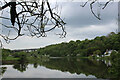
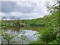
River Wear at Stony Heugh
Scene at the majestic curve of a meander in the River Wear before it reaches the outskirts of Sunderland.
The Weardale Way follows the southern bank in woods, before passing in front of the photographed Garden House, and onto the A19 viaduct.
Image: © Chris Heaton
Taken: 18 May 2023
0.05 miles
2
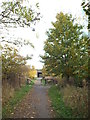
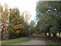
Shared cycle and pedestrian path near South Hylton
This path follows the route of a dismantled railway line heading out of Sunderland. The path is used by pedestrians and cyclists.
Image: © Malc McDonald
Taken: 29 Oct 2016
0.08 miles
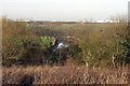
3
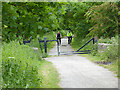
Railway path off Offerton Lane
The old railway from Sunderland to Penshaw forms a useful cycle route. At this point it diverges from Offerton Lane. The metal tubes set at an angle are designed to stop motor bikes, but are also an obstacle to pedal cycles with long handlebars. The low rail adjoining is a horse stile which horses can step over but which also should prove a deterrent to motor bikes.
Image: © Oliver Dixon
Taken: 19 Jun 2015
0.08 miles
4
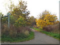
Cycle route and footpath near South Hylton
This shared use path heading out of Sunderland follows the route of a dismantled railway line.
Image: © Malc McDonald
Taken: 29 Oct 2016
0.09 miles
5
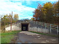
Underpass beneath the A19 near South Hylton
This underpass takes a minor road beneath the A19 trunk road on the outskirts of Sunderland. The road also forms part of a cycle route and footpath which follow the route of a dismantled railway line.
Image: © Malc McDonald
Taken: 29 Oct 2016
0.09 miles
6
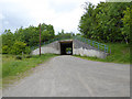
Offerton Lane
Offerton Lane passes under the A19 at this point. It forms part of a cycle route which follows the old railway from Penshaw to Sunderland.
Image: © Oliver Dixon
Taken: 19 Jun 2015
0.10 miles
8
The River Wear bends at Nab End
Taken from the path above Stony Haugh
Image: © Alan Fearon
Taken: 19 Nov 2005
0.12 miles
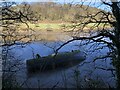
9
The Wear flowing past Stony Heugh
An attractive, tranquil part of the river before its passage through Sunderland. The outside of the river meander has cut a steep wooded bank, 'Stony Heugh'. 'Heugh' is a ridge end or hill http://epns.nottingham.ac.uk/search/p/%28placeName%3A%2Aheugh%2A%29
Image: © Tim Heaton
Taken: 18 May 2023
0.13 miles
10
Cycle and pedestrian path near South Hylton
This path, shared by cyclists and pedestrians, follows the route of a dismantled railway.
Image: © Malc McDonald
Taken: 29 Oct 2016
0.15 miles