IMAGES TAKEN NEAR TO
Greenbank Drive, SUNDERLAND, SR4 0JX
Introduction
This page details the photographs taken nearby to Greenbank Drive, SR4 0JX by members of the Geograph project.
The Geograph project started in 2005 with the aim of publishing, organising and preserving representative images for every square kilometre of Great Britain, Ireland and the Isle of Man.

There are currently over 7.5m images from over14,400 individuals and you can help contribute to the project by visiting https://www.geograph.org.uk
Image Map
Images are licensed for reuse under creativecommons.org/licenses/by-sa/2.0
Notes
- Clicking on the map will re-center to the selected point.
- The higher the marker number, the further away the image location is from the centre of the postcode.
Image Listing (10 Images Found)
Images are licensed for reuse under creativecommons.org/licenses/by-sa/2.0
Image
Details
Distance
1
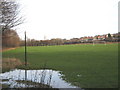
Football pitches at South Hylton Sunderland
Together with an adjacent cricket field they form a recreational area in the urban fringe of the city
Image: © Peter Robinson
Taken: 17 Jan 2010
0.08 miles
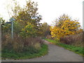
2
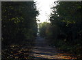
Footpath/Cycleway, South Hylton
Where the Metro line terminates the old railway route continues SW. The tunnel in the distances takes the path under the A19.
Image: © Alan Fearon
Taken: 19 Nov 2005
0.10 miles
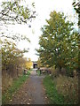
3
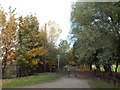
Cycle and pedestrian path near South Hylton
This path, shared by cyclists and pedestrians, follows the route of a dismantled railway.
Image: © Malc McDonald
Taken: 29 Oct 2016
0.12 miles
4
Offerton Lane
Offerton Lane passes under the A19 at this point. It forms part of a cycle route which follows the old railway from Penshaw to Sunderland.
Image: © Oliver Dixon
Taken: 19 Jun 2015
0.17 miles
5
Cycle route and footpath near South Hylton
This shared use path heading out of Sunderland follows the route of a dismantled railway line.
Image: © Malc McDonald
Taken: 29 Oct 2016
0.18 miles
6
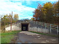
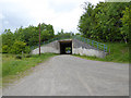
Underpass beneath the A19 near South Hylton
This underpass takes a minor road beneath the A19 trunk road on the outskirts of Sunderland. The road also forms part of a cycle route and footpath which follow the route of a dismantled railway line.
Image: © Malc McDonald
Taken: 29 Oct 2016
0.18 miles
7
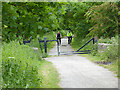
Railway path off Offerton Lane
The old railway from Sunderland to Penshaw forms a useful cycle route. At this point it diverges from Offerton Lane. The metal tubes set at an angle are designed to stop motor bikes, but are also an obstacle to pedal cycles with long handlebars. The low rail adjoining is a horse stile which horses can step over but which also should prove a deterrent to motor bikes.
Image: © Oliver Dixon
Taken: 19 Jun 2015
0.20 miles
8
Shared cycle and pedestrian path near South Hylton
This path follows the route of a dismantled railway line heading out of Sunderland. The path is used by pedestrians and cyclists.
Image: © Malc McDonald
Taken: 29 Oct 2016
0.21 miles
9
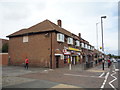
Post Office and shop on Hylton Road, Pennywell, Sunderland
Image: © JThomas
Taken: 18 Aug 2018
0.23 miles
10
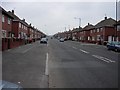
A Long Road
Hylton Road, running through Pennywell in Sunderland.
Image: © Brian Abbott
Taken: 12 May 2006
0.23 miles