IMAGES TAKEN NEAR TO
Monksfield Close, SUNDERLAND, SR3 2SB
Introduction
This page details the photographs taken nearby to Monksfield Close, SR3 2SB by members of the Geograph project.
The Geograph project started in 2005 with the aim of publishing, organising and preserving representative images for every square kilometre of Great Britain, Ireland and the Isle of Man.

There are currently over 7.5m images from over14,400 individuals and you can help contribute to the project by visiting https://www.geograph.org.uk
Image Map
Images are licensed for reuse under creativecommons.org/licenses/by-sa/2.0
Notes
- Clicking on the map will re-center to the selected point.
- The higher the marker number, the further away the image location is from the centre of the postcode.
Image Listing (7 Images Found)
Images are licensed for reuse under creativecommons.org/licenses/by-sa/2.0
Image
Details
Distance
2
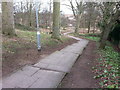
Steps on path descending to Doxford Park Way in small wood
Image: © Clive Nicholson
Taken: 2 Feb 2015
0.10 miles
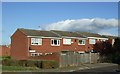
5
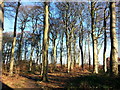
Woodland at Moorside
A small segment of old woodland sandwiched between more modern housing.
Image: © Clive Nicholson
Taken: 8 Jan 2015
0.14 miles
6
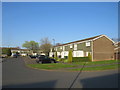
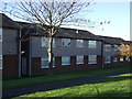
Maree Close, Moorside, Sunderland
Maree Close is a residential cul-de-sac in the suburbs of Sunderland.
Image: © Malc McDonald
Taken: 21 Apr 2019
0.23 miles
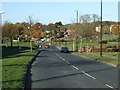
7
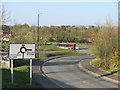
Moorside Road, Moorside, Sunderland
Moorside Road in the southern suburbs of Sunderland.
Image: © Malc McDonald
Taken: 21 Apr 2019
0.25 miles