IMAGES TAKEN NEAR TO
Wetherby Road, SUNDERLAND, SR2 9SW
Introduction
This page details the photographs taken nearby to Wetherby Road, SR2 9SW by members of the Geograph project.
The Geograph project started in 2005 with the aim of publishing, organising and preserving representative images for every square kilometre of Great Britain, Ireland and the Isle of Man.

There are currently over 7.5m images from over14,400 individuals and you can help contribute to the project by visiting https://www.geograph.org.uk
Image Map
Images are licensed for reuse under creativecommons.org/licenses/by-sa/2.0
Notes
- Clicking on the map will re-center to the selected point.
- The higher the marker number, the further away the image location is from the centre of the postcode.
Image Listing (17 Images Found)
Images are licensed for reuse under creativecommons.org/licenses/by-sa/2.0
Image
Details
Distance


4

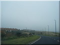
Railway Bridge over the A1018 at Hendon in Sunderland
Image: © Peter Robinson
Taken: 26 May 2013
0.14 miles
6

Ordnance Survey Cut Mark
This OS cut mark can be found on the west face of St Aidan's Church. It marks a point 36.954m above mean sea level.
Image: © Adrian Dust
Taken: 19 Sep 2018
0.20 miles
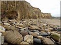
7

Yellow and green
Sea-eroded magnesian limestone cliffs weathered to an attractive yellow contrast with green algae-covered slabs on the beach.
Image: © Andrew Curtis
Taken: 9 Oct 2009
0.21 miles
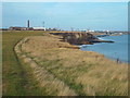
8
Cliffs of magnesian limestone north of Salterfen Rocks
Image: © Andrew Curtis
Taken: 9 Oct 2009
0.21 miles
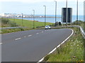
9
England Coast Path approaching Sunderland
Image: © Malc McDonald
Taken: 30 Oct 2016
0.21 miles
10

Yellow sandstone & brown rocks
A sea-worn exposure of the bright yellow sandstone that lies beneath the magnesian limestone which makes up the cliff line. Boulders formed from erosion of the limestone are weathered to a yellow-brown.
Image: © Andrew Curtis
Taken: 9 Oct 2009
0.22 miles