IMAGES TAKEN NEAR TO
Westminster Street, SUNDERLAND, SR2 9QP
Introduction
This page details the photographs taken nearby to Westminster Street, SR2 9QP by members of the Geograph project.
The Geograph project started in 2005 with the aim of publishing, organising and preserving representative images for every square kilometre of Great Britain, Ireland and the Isle of Man.

There are currently over 7.5m images from over14,400 individuals and you can help contribute to the project by visiting https://www.geograph.org.uk
Image Map
Images are licensed for reuse under creativecommons.org/licenses/by-sa/2.0
Notes
- Clicking on the map will re-center to the selected point.
- The higher the marker number, the further away the image location is from the centre of the postcode.
Image Listing (30 Images Found)
Images are licensed for reuse under creativecommons.org/licenses/by-sa/2.0
Image
Details
Distance
3
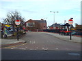
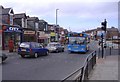
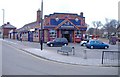
Grangetown bus terminus, Sunderland
A small terminus for buses in Grangetown, a suburb of Sunderland.
Image: © Malc McDonald
Taken: 30 Oct 2016
0.06 miles
7
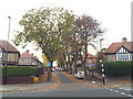
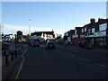
Woodstock Avenue, Grangetown, Sunderland
Woodstock Avenue is a residential cul-de-sac in Grangetown, a suburb of Sunderland.
Image: © Malc McDonald
Taken: 30 Oct 2016
0.12 miles
8

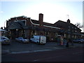
Ordnance Survey Cut Mark
This OS cut mark can be found on the west face of St Aidan's Church. It marks a point 36.954m above mean sea level.
Image: © Adrian Dust
Taken: 19 Sep 2018
0.12 miles

