IMAGES TAKEN NEAR TO
Old Mill Road, SUNDERLAND, SR2 8NU
Introduction
This page details the photographs taken nearby to Old Mill Road, SR2 8NU by members of the Geograph project.
The Geograph project started in 2005 with the aim of publishing, organising and preserving representative images for every square kilometre of Great Britain, Ireland and the Isle of Man.

There are currently over 7.5m images from over14,400 individuals and you can help contribute to the project by visiting https://www.geograph.org.uk
Image Map
Images are licensed for reuse under creativecommons.org/licenses/by-sa/2.0
Notes
- Clicking on the map will re-center to the selected point.
- The higher the marker number, the further away the image location is from the centre of the postcode.
Image Listing (15 Images Found)
Images are licensed for reuse under creativecommons.org/licenses/by-sa/2.0
Image
Details
Distance
1
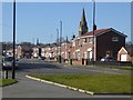
Gray Road, Sunderland
Suburban street in Hendon, Sunderland. The church is that of St Ignatius the Martyr in Bramwell Road, an Anglo-Catholic church, dating from 1889 and Grade 2 listed.
Image: © Oliver Dixon
Taken: 23 Feb 2016
0.16 miles
2
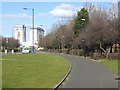
Commercial Road, Hendon
The footway on the eastern side of Commercial Road (A1018) carries the England Coast Path round and just outside the centre of the city of Sunderland.
Image: © Oliver Dixon
Taken: 23 Feb 2016
0.16 miles
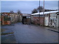
3
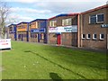
Commercial premises, Hendon Industrial Estate
On the edge of the estate, backing onto Hendon Road. Appearances are deceptive - this view of the rear of the premises belies the busy frontages on the other side of the building.
Image: © Oliver Dixon
Taken: 23 Feb 2016
0.16 miles
5
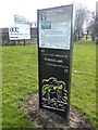
Interpretive panel beside Hendon Road
One of the numerous interpretive panels set up by Sunderland City Council commemorating the city's industrial past. This particular panel commemorates the luckless George Hudson who was heavily involved in developing local railways and the South Dock at Sunderland. The sign stands beside the recently-established National Trail - the England Coast Path.
Image: © Oliver Dixon
Taken: 23 Feb 2016
0.20 miles
7
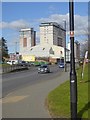
Hendon Road, Sunderland
The footway on the eastern side of Hendon Road (A1018) carries the England Coast Path just outside the centre of the city of Sunderland.
Image: © Oliver Dixon
Taken: 23 Feb 2016
0.22 miles
8
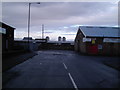
Extension Road
This is Extension Road leading to Hendon Docks.
Image: © MSX
Taken: 4 Dec 2005
0.22 miles
9
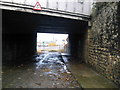
Extension Street Railway Bridge
Further into NZ4056.
Image: © MSX
Taken: 4 Dec 2005
0.22 miles
10
The Parade
Frivolously titled street in this industrial wasteland, Note stray horses behind quaint, old, tumbledown wall.
Image: © MSX
Taken: 4 Dec 2005
0.22 miles