IMAGES TAKEN NEAR TO
Henry Street East, SUNDERLAND, SR2 8AU
Introduction
This page details the photographs taken nearby to Henry Street East, SR2 8AU by members of the Geograph project.
The Geograph project started in 2005 with the aim of publishing, organising and preserving representative images for every square kilometre of Great Britain, Ireland and the Isle of Man.

There are currently over 7.5m images from over14,400 individuals and you can help contribute to the project by visiting https://www.geograph.org.uk
Image Map
Images are licensed for reuse under creativecommons.org/licenses/by-sa/2.0
Notes
- Clicking on the map will re-center to the selected point.
- The higher the marker number, the further away the image location is from the centre of the postcode.
Image Listing (34 Images Found)
Images are licensed for reuse under creativecommons.org/licenses/by-sa/2.0
Image
Details
Distance
4
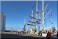
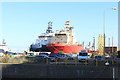
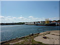
The QE2 Berth, Port of Sunderland
The large area of concrete along the Port of Sunderland's QE2 Berth seen during the Tall Ships Races 2018 start event held in the city. The ship docked closest to the camera is Lord Nelson.
Image: © Graham Robson
Taken: 12 Jul 2018
0.15 miles
5
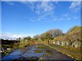
Derelict site off Moor Terrace
This lies between the Town Moor, over the wall on the left, and the former railway to the Hudson Docks.
Image: © Robert Graham
Taken: 17 Oct 2016
0.16 miles
6
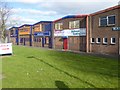
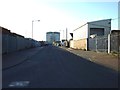
Commercial premises, Hendon Industrial Estate
On the edge of the estate, backing onto Hendon Road. Appearances are deceptive - this view of the rear of the premises belies the busy frontages on the other side of the building.
Image: © Oliver Dixon
Taken: 23 Feb 2016
0.17 miles
7
Ships in Hendon Dock, Port of Sunderland
Looking across the quay separating Hudson Dock and Hendon Dock towards a pair of large off shore supply ships moored in the latter. UP Jasper in the vessel with the red coloured hull.
Image: © Graham Robson
Taken: 12 Jul 2018
0.17 miles
8
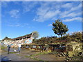
Former railway embankment
Derelict site beside the former railway to Hudson Docks in east Sunderland. The chap with the binoculars is here because a rare bird had turned up.
Image: © Robert Graham
Taken: 17 Oct 2016
0.17 miles
10
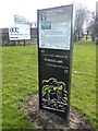
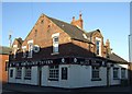
Interpretive panel beside Hendon Road
One of the numerous interpretive panels set up by Sunderland City Council commemorating the city's industrial past. This particular panel commemorates the luckless George Hudson who was heavily involved in developing local railways and the South Dock at Sunderland. The sign stands beside the recently-established National Trail - the England Coast Path.
Image: © Oliver Dixon
Taken: 23 Feb 2016
0.17 miles