IMAGES TAKEN NEAR TO
Mordey Close, SUNDERLAND, SR2 8AQ
Introduction
This page details the photographs taken nearby to Mordey Close, SR2 8AQ by members of the Geograph project.
The Geograph project started in 2005 with the aim of publishing, organising and preserving representative images for every square kilometre of Great Britain, Ireland and the Isle of Man.

There are currently over 7.5m images from over14,400 individuals and you can help contribute to the project by visiting https://www.geograph.org.uk
Image Map
Images are licensed for reuse under creativecommons.org/licenses/by-sa/2.0
Notes
- Clicking on the map will re-center to the selected point.
- The higher the marker number, the further away the image location is from the centre of the postcode.
Image Listing (20 Images Found)
Images are licensed for reuse under creativecommons.org/licenses/by-sa/2.0
Image
Details
Distance
1
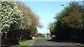
White House Road, Sunderland
This image was taken in the month of April, while trees were in blossom.
Image: © Malc McDonald
Taken: 18 Apr 2014
0.06 miles
2
Extension Road
This is Extension Road leading to Hendon Docks.
Image: © MSX
Taken: 4 Dec 2005
0.08 miles
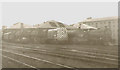
3
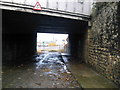
Extension Street Railway Bridge
Further into NZ4056.
Image: © MSX
Taken: 4 Dec 2005
0.08 miles
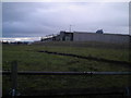
4
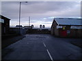
The Parade
Frivolously titled street in this industrial wasteland, Note stray horses behind quaint, old, tumbledown wall.
Image: © MSX
Taken: 4 Dec 2005
0.08 miles
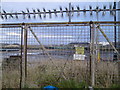
5
Henry Street East
More uneasy industrial menace.
Image: © MSX
Taken: 4 Dec 2005
0.08 miles
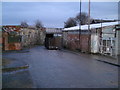
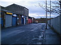
6
More Industrial Estate
Unkempt light industrial area.
Image: © MSX
Taken: 4 Dec 2005
0.08 miles
7
More 4056
Guess what, more industrial decrepitude.
Image: © MSX
Taken: 4 Dec 2005
0.08 miles
9
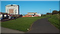
Path in Hendon, Sunderland
This path, through the district of Hendon, followis the route of a railway which used to serve Sunderland's docks.
Image: © Malc McDonald
Taken: 18 Apr 2014
0.09 miles
