IMAGES TAKEN NEAR TO
Ranson Street, SUNDERLAND, SR2 7QR
Introduction
This page details the photographs taken nearby to Ranson Street, SR2 7QR by members of the Geograph project.
The Geograph project started in 2005 with the aim of publishing, organising and preserving representative images for every square kilometre of Great Britain, Ireland and the Isle of Man.

There are currently over 7.5m images from over14,400 individuals and you can help contribute to the project by visiting https://www.geograph.org.uk
Image Map
Images are licensed for reuse under creativecommons.org/licenses/by-sa/2.0
Notes
- Clicking on the map will re-center to the selected point.
- The higher the marker number, the further away the image location is from the centre of the postcode.
Image Listing (13 Images Found)
Images are licensed for reuse under creativecommons.org/licenses/by-sa/2.0
Image
Details
Distance
1
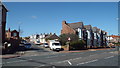
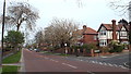
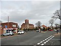
Ranson Street, Sunderland
Ranson Street is a residential street leading off Durham Road in Sunderland.
Image: © Malc McDonald
Taken: 19 Apr 2014
0.03 miles
2
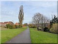
Cycle- and foot-path in Sunderland
Following a green corridor along the line of the former Hetton Colliery Railway.
Image: © Oliver Dixon
Taken: 15 Nov 2016
0.06 miles
4
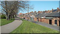
Path past backyards, Sunderland
This raised path follows the route of a former railway into Sunderland. The path forms part of the National Cycle Network route 1, a long distance route linking Dover with the Shetland Islands.
Image: © Malc McDonald
Taken: 19 Apr 2014
0.11 miles
5
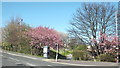
Cycle route NCN1 in Sunderland
The path in the centre of the image forms part of National Cycle Network route 1 (NCN1), a long-distance cycle route from Dover to the Shetland islands up the eastern side of Britain. The path follows the route of a former railway into Sunderland.
This image was taken in April, while trees were in blossom.
Image: © Malc McDonald
Taken: 19 Apr 2014
0.12 miles
8
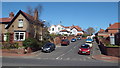
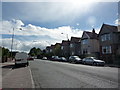
Queen Alexandra Road, Sunderland
Queen Alexandra Road in Ashbrooke, a suburb of Sunderland.
Image: © Malc McDonald
Taken: 20 Apr 2014
0.22 miles
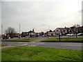
9
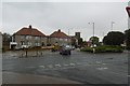
Junction of Silksworth Lane with Queen Alexandra Road
Min road in the western suburbs of Sunderland. St Nicholas Church across the road.
Image: © Robert Graham
Taken: 15 Mar 2017
0.22 miles
10
Junction of Queen Alexander Road with Durham Road
On the west side of Sunderland. Durham Road is the A690, the main SW route out of the city centre.
Image: © Robert Graham
Taken: 15 Mar 2017
0.23 miles