IMAGES TAKEN NEAR TO
Cedars Court, SUNDERLAND, SR2 7EN
Introduction
This page details the photographs taken nearby to Cedars Court, SR2 7EN by members of the Geograph project.
The Geograph project started in 2005 with the aim of publishing, organising and preserving representative images for every square kilometre of Great Britain, Ireland and the Isle of Man.

There are currently over 7.5m images from over14,400 individuals and you can help contribute to the project by visiting https://www.geograph.org.uk
Image Map
Images are licensed for reuse under creativecommons.org/licenses/by-sa/2.0
Notes
- Clicking on the map will re-center to the selected point.
- The higher the marker number, the further away the image location is from the centre of the postcode.
Image Listing (26 Images Found)
Images are licensed for reuse under creativecommons.org/licenses/by-sa/2.0
Image
Details
Distance
1

Hammerton House
3rd Durham VA Hospital during the First World War.
Image: © Patrick Brennan - donmouth.co.uk
Taken: 29 Sep 2007
0.06 miles
2
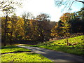
Autumn colours, Backhouse Park, Sunderland
November sunshine in Backhouse Park, Sunderland
Image: © Malc McDonald
Taken: 1 Nov 2014
0.07 miles
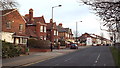
3

Ryhope Road, Sunderland
Ryhope Road in Sunderland, taken at night. Ryhope Road is a dual carriageway.
Image: © Malc McDonald
Taken: 19 Apr 2014
0.08 miles
4

Ashburne House
25th Durham VA Hospital in First World War. Now incorporated into Sunderland University Department of Arts and Design.
Image: © Patrick Brennan - donmouth.co.uk
Taken: 29 Sep 2007
0.10 miles
5

Barley Mow Park, Sunderland
Barley Mow Park is a small park in Sunderland.
Image: © Malc McDonald
Taken: 8 Mar 2014
0.11 miles
6
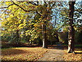
Autumn in Backhouse Park, Sunderland
Autumn leaves in Backhouse Park, Sunderland
Image: © Malc McDonald
Taken: 1 Nov 2014
0.11 miles

8
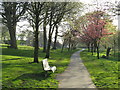
Spring colour in Backhouse Park, Sunderland
Spring colour photographed during the early evening, in Backhouse Park in Sunderland.
Image: © Malc McDonald
Taken: 20 Apr 2019
0.13 miles
9
Ryhope Road, Sunderland
Ryhope Road is a dual-carriageway. This image was taken from the central reservation, looking south along the southbound carriageway.
Image: © Malc McDonald
Taken: 8 Mar 2014
0.14 miles
10

Langham Tower, Sunderland High School
Image: © Alexander P Kapp
Taken: 24 May 2011
0.14 miles