IMAGES TAKEN NEAR TO
Ladock Close, SUNDERLAND, SR2 0YY
Introduction
This page details the photographs taken nearby to Ladock Close, SR2 0YY by members of the Geograph project.
The Geograph project started in 2005 with the aim of publishing, organising and preserving representative images for every square kilometre of Great Britain, Ireland and the Isle of Man.

There are currently over 7.5m images from over14,400 individuals and you can help contribute to the project by visiting https://www.geograph.org.uk
Image Map
Images are licensed for reuse under creativecommons.org/licenses/by-sa/2.0
Notes
- Clicking on the map will re-center to the selected point.
- The higher the marker number, the further away the image location is from the centre of the postcode.
Image Listing (14 Images Found)
Images are licensed for reuse under creativecommons.org/licenses/by-sa/2.0
Image
Details
Distance

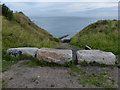
2
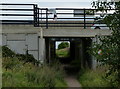
Salterfen Lane leading to the beach at Ryhope Nook
The lane is passing under the A1018.
Image: © Mat Fascione
Taken: 27 Aug 2017
0.10 miles
3
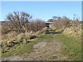
The path up from Ryhope Nook
Passing under the Sunderland to Middlesbrough railway.
Image: © Oliver Dixon
Taken: 23 Feb 2016
0.12 miles
4
Salterfen Lane descending to the beach at Ryhope Nook
Image: © Mat Fascione
Taken: 27 Aug 2017
0.20 miles
5
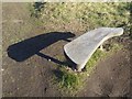
Bench above Ryhope Nook
Inscribed "Sitting listening wishing".
Image: © Oliver Dixon
Taken: 23 Feb 2016
0.22 miles
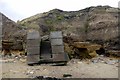
6
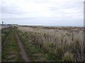
Grassland between railway and cliff-top, Ryehope
Image: © Andrew Curtis
Taken: 9 Oct 2009
0.22 miles
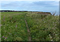
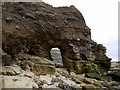
8
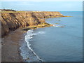
Coastline near Ryhope
The coastline of the North Sea near Ryhope. A natural arch has formed in the rock in the middle of the image.
Sunderland is visible in the distance.
Image: © Malc McDonald
Taken: 30 Oct 2016
0.23 miles