IMAGES TAKEN NEAR TO
Ryhope, SUNDERLAND, SR2 0SS
Introduction
This page details the photographs taken nearby to SR2 0SS by members of the Geograph project.
The Geograph project started in 2005 with the aim of publishing, organising and preserving representative images for every square kilometre of Great Britain, Ireland and the Isle of Man.

There are currently over 7.5m images from over14,400 individuals and you can help contribute to the project by visiting https://www.geograph.org.uk
Image Map
Images are licensed for reuse under creativecommons.org/licenses/by-sa/2.0
Notes
- Clicking on the map will re-center to the selected point.
- The higher the marker number, the further away the image location is from the centre of the postcode.
Image Listing (7 Images Found)
Images are licensed for reuse under creativecommons.org/licenses/by-sa/2.0
Image
Details
Distance
1
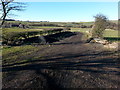
Bridleway that crosses National Cycle Route 1 heading towards West Cherry Knowle
Image: © Clive Nicholson
Taken: 9 Feb 2015
0.17 miles
2
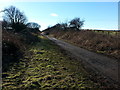
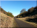
National Cycle Route 1 east of West Cherry Knowle
Image: © Clive Nicholson
Taken: 9 Feb 2015
0.17 miles
3
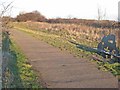
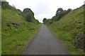
National Cycle Network route 1 near Seaham Grange
National Cycle Network Link http://www.sustrans.org.uk/default.asp?sID=1089735289781 route 1 is the principal long-distance cycle route up the east side of Britain. Here (between South Hetton and Ryhope) it follows a long length of the disused railway. The design of the seat reflects the railway history of the route in an imaginative way.
Image: © Oliver Dixon
Taken: 16 Jan 2007
0.19 miles
4
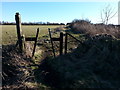
Bridleway that crosses National Cycle Route 1 east of West Cherry Knowle
Image: © Clive Nicholson
Taken: 9 Feb 2015
0.19 miles
5
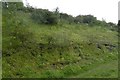
Cutting, Durham and Sunderland Railway
West of Seaham on a steep gradient.
Image: © Richard Webb
Taken: 9 Aug 2016
0.21 miles
6
National Cycle Route 1 south of West Cherry Knowle
Image: © Clive Nicholson
Taken: 9 Feb 2015
0.22 miles
7
Durham and Sunderland Railway trackbed
Cutting on a steep gradient west of Seaham.
Image: © Richard Webb
Taken: 9 Aug 2016
0.22 miles