IMAGES TAKEN NEAR TO
Cliffe View, SUNDERLAND, SR2 0NL
Introduction
This page details the photographs taken nearby to Cliffe View, SR2 0NL by members of the Geograph project.
The Geograph project started in 2005 with the aim of publishing, organising and preserving representative images for every square kilometre of Great Britain, Ireland and the Isle of Man.

There are currently over 7.5m images from over14,400 individuals and you can help contribute to the project by visiting https://www.geograph.org.uk
Image Map
Images are licensed for reuse under creativecommons.org/licenses/by-sa/2.0
Notes
- Clicking on the map will re-center to the selected point.
- The higher the marker number, the further away the image location is from the centre of the postcode.
Image Listing (50 Images Found)
Images are licensed for reuse under creativecommons.org/licenses/by-sa/2.0
Image
Details
Distance
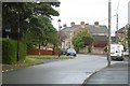
5
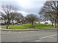
Ryhope village green
A suburb of Sunderland.
Image: © Oliver Dixon
Taken: 16 Feb 2016
0.07 miles
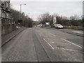
8
Silksworth Colliery Railway
Rails to trails conversion near where the railway joined the mainline between Seaham and Sunderland.
Image: © Richard Webb
Taken: 9 Aug 2016
0.10 miles
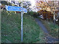
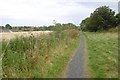
9
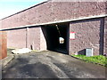
Bridleway to Ryhope Beach under road and rail bridges
Image: © Clive Nicholson
Taken: 3 Mar 2014
0.12 miles
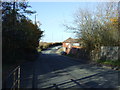
10
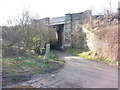
Railway Bridge over bridleway to Ryhope Beach
Image: © Clive Nicholson
Taken: 3 Mar 2014
0.12 miles