IMAGES TAKEN NEAR TO
Barrack Street, SUNDERLAND, SR1 2EG
Introduction
This page details the photographs taken nearby to Barrack Street, SR1 2EG by members of the Geograph project.
The Geograph project started in 2005 with the aim of publishing, organising and preserving representative images for every square kilometre of Great Britain, Ireland and the Isle of Man.

There are currently over 7.5m images from over14,400 individuals and you can help contribute to the project by visiting https://www.geograph.org.uk
Image Map
Images are licensed for reuse under creativecommons.org/licenses/by-sa/2.0
Notes
- Clicking on the map will re-center to the selected point.
- The higher the marker number, the further away the image location is from the centre of the postcode.
Image Listing (93 Images Found)
Images are licensed for reuse under creativecommons.org/licenses/by-sa/2.0
Image
Details
Distance
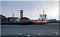
1
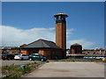
Port Control Office, Sunderland Harbour
Image: © Alexander P Kapp
Taken: 24 May 2011
0.00 miles
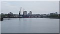
2
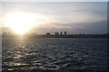
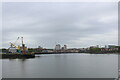
Looking back to Sunderland
Taken on a very cold and windy day from the pier at the Wearmouth, looking back to Sunderland
Image: © hayley green
Taken: 18 Jan 2009
0.04 miles
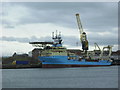
3
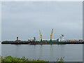
The MV Cellus at Greenwells Quay, Port of Sunderland
Image: © Tim Heaton
Taken: 19 May 2023
0.06 miles
5
Sunderland Port Control, 19th February 2005.
Image: © Martin Routledge
Taken: 19 Feb 2005
0.07 miles
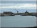
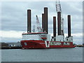
9
Sunderland Harbour from North Pier
Looking back towards the City of Sunderland, from the Weardale Way close to North Pier
Image: © Chris Heaton
Taken: 19 May 2023
0.10 miles
10
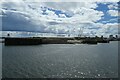
Mouth of the Wear
Looking across the River Wear as it enters the sea at Sunderland harbour.
Image: © DS Pugh
Taken: 2 Jul 2022
0.11 miles