IMAGES TAKEN NEAR TO
Villiers Street South, SUNDERLAND, SR1 2AH
Introduction
This page details the photographs taken nearby to Villiers Street South, SR1 2AH by members of the Geograph project.
The Geograph project started in 2005 with the aim of publishing, organising and preserving representative images for every square kilometre of Great Britain, Ireland and the Isle of Man.

There are currently over 7.5m images from over14,400 individuals and you can help contribute to the project by visiting https://www.geograph.org.uk
Image Map
Images are licensed for reuse under creativecommons.org/licenses/by-sa/2.0
Notes
- Clicking on the map will re-center to the selected point.
- The higher the marker number, the further away the image location is from the centre of the postcode.
Image Listing (55 Images Found)
Images are licensed for reuse under creativecommons.org/licenses/by-sa/2.0
Image
Details
Distance
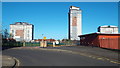
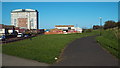
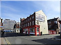
2
Villiers Street South, Sunderland
The disused industrial building on the opposite side of the road contrasts with the more modern block of flats in the background.
Image: © Malc McDonald
Taken: 18 Apr 2014
0.03 miles
3
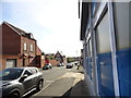
View down Villiers Street, Sunderland
Looking down to the Emmanuel Free Church at the bottom.
Image: © Robert Graham
Taken: 3 Oct 2016
0.09 miles
4
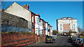
Hudson Road, Sunderland
A contrast between older housing on the left hand side of the road and a more recent block of flats in the background.
Image: © Malc McDonald
Taken: 18 Apr 2014
0.10 miles
5
Path in Hendon, Sunderland
This path, through the district of Hendon, followis the route of a railway which used to serve Sunderland's docks.
Image: © Malc McDonald
Taken: 18 Apr 2014
0.12 miles
6
Hudson Road, Sunderland
Looking southeast from Borough Road. This is the less fashionable east end of the city.
Image: © Robert Graham
Taken: 3 Oct 2016
0.12 miles
7
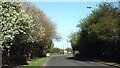
White House Road, Sunderland
This image was taken in the month of April, while trees were in blossom.
Image: © Malc McDonald
Taken: 18 Apr 2014
0.14 miles
8
Junction of Borough Road with Tatham Street
East of Sunderland city centre.
Image: © Robert Graham
Taken: 3 Oct 2016
0.14 miles
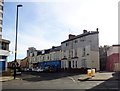
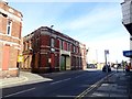
9
The Burton House
Old pub on Borough Road east of the city centre in Sunderland. At first floor level can still be seen the sign for Vaux Breweries, meaning this was once one of their tied houses. This brewery was a major employer in Sunderland, with a huge brewery on the banks of the Wear. Sadly now all gone, although some of the original beer is still produced by a small local brewer.
Image: © Robert Graham
Taken: 3 Oct 2016
0.14 miles
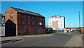
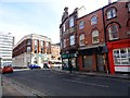
10
Warehouses on Borough Road, Sunderland
Moving east from the city centre into the former industrial areas.
Image: © Robert Graham
Taken: 3 Oct 2016
0.15 miles