IMAGES TAKEN NEAR TO
Hope Cross, GILLINGHAM, SP8 5SS
Introduction
This page details the photographs taken nearby to Hope Cross, SP8 5SS by members of the Geograph project.
The Geograph project started in 2005 with the aim of publishing, organising and preserving representative images for every square kilometre of Great Britain, Ireland and the Isle of Man.

There are currently over 7.5m images from over14,400 individuals and you can help contribute to the project by visiting https://www.geograph.org.uk
Image Map
Images are licensed for reuse under creativecommons.org/licenses/by-sa/2.0
Notes
- Clicking on the map will re-center to the selected point.
- The higher the marker number, the further away the image location is from the centre of the postcode.
Image Listing (1 Images Found)
Images are licensed for reuse under creativecommons.org/licenses/by-sa/2.0
Image
Details
Distance
1
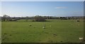
Sheep near Buckhorn Weston
A field crossed by drainage channels (you can see a bridge over one on the right), with Tom Thumb Farm in the background, and houses at Hope Cross on the right. Seen from a train on the railway line east of Templecombe.
Image: © Derek Harper
Taken: 29 Apr 2013
0.20 miles