IMAGES TAKEN NEAR TO
Bleet Lane, GILLINGHAM, SP8 5RG
Introduction
This page details the photographs taken nearby to Bleet Lane, SP8 5RG by members of the Geograph project.
The Geograph project started in 2005 with the aim of publishing, organising and preserving representative images for every square kilometre of Great Britain, Ireland and the Isle of Man.

There are currently over 7.5m images from over14,400 individuals and you can help contribute to the project by visiting https://www.geograph.org.uk
Image Map
Images are licensed for reuse under creativecommons.org/licenses/by-sa/2.0
Notes
- Clicking on the map will re-center to the selected point.
- The higher the marker number, the further away the image location is from the centre of the postcode.
Image Listing (6 Images Found)
Images are licensed for reuse under creativecommons.org/licenses/by-sa/2.0
Image
Details
Distance
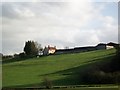
4
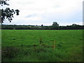
Farmland off Bleet Lane
A view looking to the southeast across farmland off Bleet Lane. Buildings at East Stour can be seen in the distance.
Image: © Phil Williams
Taken: 20 Jul 2007
0.15 miles
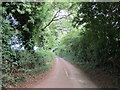
6
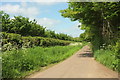
Folly Lane
From the start of Standpitts Lane to the right of the camera. The track is followed by the parish boundary between East Stour (left) and Gillingham.
Image: © Derek Harper
Taken: 26 May 2016
0.23 miles