IMAGES TAKEN NEAR TO
Cole Street Lane, GILLINGHAM, SP8 5JQ
Introduction
This page details the photographs taken nearby to Cole Street Lane, SP8 5JQ by members of the Geograph project.
The Geograph project started in 2005 with the aim of publishing, organising and preserving representative images for every square kilometre of Great Britain, Ireland and the Isle of Man.

There are currently over 7.5m images from over14,400 individuals and you can help contribute to the project by visiting https://www.geograph.org.uk
Image Map
Images are licensed for reuse under creativecommons.org/licenses/by-sa/2.0
Notes
- Clicking on the map will re-center to the selected point.
- The higher the marker number, the further away the image location is from the centre of the postcode.
Image Listing (22 Images Found)
Images are licensed for reuse under creativecommons.org/licenses/by-sa/2.0
Image
Details
Distance
1
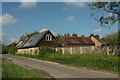
Cole Street Farm
On Cole Street Lane. "The Threshold Centre at Cole Street Farm is a unique, pioneering cohousing community and sustainable education centre, which aims to demonstrate a way of life, which is more green, affordable, and neighbourly" http://www.thresholdcentre.org.uk/ . The "cohousing scheme at Cole Street Farm ... consists of fourteen dwellings".
Image: © Derek Harper
Taken: 26 May 2016
0.01 miles
2
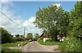
Cole Street Lane
Approaching The Threshold Centre at Cole Street Farm, more clearly shown and described at Image
Image: © Derek Harper
Taken: 26 May 2016
0.01 miles
3
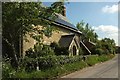
Cole Street Farm
The farmhouse that now forms part of a cohousing project, the Threshold Centre http://www.thresholdcentre.org.uk/ .
Image: © Derek Harper
Taken: 26 May 2016
0.03 miles
4

Cole Street Lane
Just approaching the scene in Image
Image: © Derek Harper
Taken: 26 May 2016
0.09 miles
5
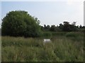
Pond in field south of Cole Street Farm
Image: © Becky Williamson
Taken: 15 Sep 2016
0.12 miles
6

Towards Cole Street Lane
Footpath N64 33 runs along the edge of this field towards the buildings on Cole Street Lane, with Duncliffe Hill in the background. Meanwhile footpath N64 78 veers away to the left across the same field.
Image: © Derek Harper
Taken: 26 May 2016
0.13 miles
7
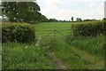
Gate and field, Cole Street Lane
The field boundary with its line of trees can be seen in Image
Image: © Derek Harper
Taken: 26 May 2016
0.13 miles
8
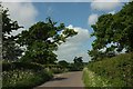
Cole Street Lane
A little west of Image], and capturing that time of year when cow parsley whitens the roadsides.
Image: © Derek Harper
Taken: 26 May 2016
0.13 miles
9
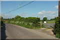
Cole Street Lane
The gate on the right is the start of footpath N64 78, though I suppose in theory you should use the overgrown stile beside it, were it possible to do so. The lane meanders past farm on its way from the B3082 to the B3092 at Madjeston.
Image: © Derek Harper
Taken: 26 May 2016
0.14 miles
10
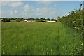
Meadow by Cole Street Lane
From footpath N64 79. The farm is Meadow Brook Farm; some buildings are in the next square.
Image: © Derek Harper
Taken: 26 May 2016
0.14 miles